Map or Atlas
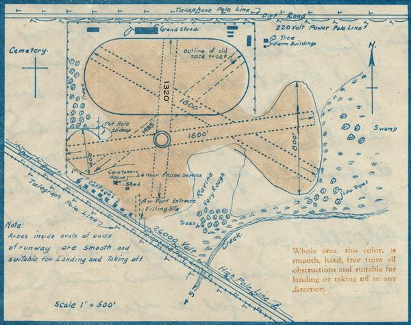
Rhinelander Airport Map

| Map of Oneida County-Rhinelander Airport which was laid out at the county fairgrounds. The map appears on the reverse side of a letter Roy Larson received from the Rhinelander airport managers. The entire pink area, they noted, "is smooth, hard, free from all obstructions and suitable for landing or taking off in any direction." The airport management also reminded potential users: "Official government statistics, in both Europe and the United States, show that there are less accidents, in proportion to the number of persons carried, in air travel than in auto travel. This letter appears in the records of the Larson Brothers Airport housed in the Historical Society's area research center at the University of Wisconsin-Oshkosh. |
| Image ID: | 10721 |
|---|---|
| Creation Date: | circa 1923 |
| Creator Name: | Unknown |
| City: | Rhinelander |
| County: | Oneida |
| State: | Wisconsin |
| Collection Name: | Larson Brothers Airport, Larson, Wisconsin, records, 1922-1929, 1965 |
| Genre: | Map or Atlas |
| Original Format Type: | manuscript |
| Original Format Number: | Oshkosh SC 62 |
| Original Dimensions: | 6 x 4.75 inches |
| Cities and towns |
| Cemeteries |
| Farm buildings |
| Airports |
| Rivers |
| This image is issued by the Wisconsin Historical Society. Use of the image requires written permission from the staff of the Collections Division. It may not be sold or redistributed, copied or distributed as a photograph, electronic file, or any other media. The image should not be significantly altered through conventional or electronic means. Images altered beyond standard cropping and resizing require further negotiation with a staff member. The user is responsible for all issues of copyright. Please Credit: Wisconsin Historical Society. |
| Location: | Wisconsin Historical Society Archives, 4th Floor, Madison, Wisconsin |
|---|
