Filter: Categories of Wisconsin Historical Images
Filter: Type of Map or Atlas
Filter: Categories of Wisconsin Historical Images
Filter: Type of Map or Atlas

| Date: | 1875 |
|---|---|
| Description: | The City of Fort Howard, Brown County, Wisconsin. Compiled from the records and drawn by F.E. Predergast, of De Pere. |

| Date: | 1896 |
|---|---|
| Description: | A map of Lincoln, Oneida, and Vilas counties, which also includes part of Iron, Price, and Langlade counties. |
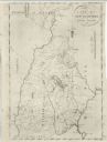
| Date: | 1833 |
|---|---|
| Description: | The map shows the distance of each dwelling-house from the common. The dwellings are listed by name of owner. |

| Date: | |
|---|---|
| Description: | A photocopy of the T.34N, R.8E portion of a map of Lincoln County. |

| Date: | 1902 |
|---|---|
| Description: | A plat map of Lincoln County showing Township 34 North, Range 8 East. |

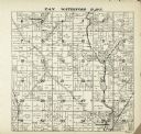
| Date: | 1909 |
|---|---|
| Description: | This the second of a set of two topographical maps showing land use, roads, railroads, bridges, and buildings with ownership in parts of LaFayette, Greenfi... |

| Date: | 1671 |
|---|---|
| Description: | Map of Virginia depicting the discoveries detailed by John Smith in his exploration of the region. It shows Jamestown, Native American tribes and villages,... |

| Date: | 1719 |
|---|---|
| Description: | Map of Maryland and surrounding states. It shows the boundaries, counties, cities, towns, rivers, and bays. Mountains, forests, and swamps appear pictoria... |

| Date: | 1795 |
|---|---|
| Description: | Map of Connecticut showing counties, townships, cities, roads, islands, swamps, hills, mountains, lakes, rivers, reefs, and numerous other geographical and... |

| Date: | 1758 |
|---|---|
| Description: | Map of Rhode Island and Connecticut, showing counties, townships, cities, roads, islands, mountains, lakes and rivers. Trees and a frame decorates the titl... |

| Date: | 1795 |
|---|---|
| Description: | Map of Rhode Island showing counties, townships, cities, roads, mountains, swamps, islands, reefs, lakes and rivers. Several of the bigger cities include s... |

| Date: | 1799 |
|---|---|
| Description: | Map of Rhode Island showing counties, townships, cities, roads, mountains, swamps, islands, reefs, lakes and rivers. Several of the bigger cities include s... |

| Date: | 1780 |
|---|---|
| Description: | Map of Connecticut, Rhode Island, and Long Island. it shows the borders, cities, roads, islands, mountains, lakes and rivers. Navigational hazards along th... |

| Date: | 1795 |
|---|---|
| Description: | Map of Massachusetts showing counties, cities, roads, islands (including Nantucket and Martha's Vineyard), mountains, hills, lakes, and rivers. Two small e... |

| Date: | 1795 |
|---|---|
| Description: | Map of Vermont showing counties, townships, cities, roads, mountains, lakes, and rivers. A forest and waterfall scene decorates the title cartouche in the ... |
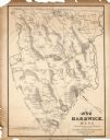
| Date: | 1791 |
|---|---|
| Description: | Detailed map of New Hampshire. It shows counties, cities, mountains, highlands, lakes, and rivers. The acres given to Dartmouth College are labeled far in ... |

| Date: | 1795 |
|---|---|
| Description: | Map of Maine, showing a few cities, harbors, hills, mountains, lakes, and rivers. A road runs from Pownalboro south to Portsmouth harbor, and the boundary ... |

| Date: | 1780 |
|---|---|
| Description: | Map of eastern Massachusetts, Rhode Island, eastern Connecticut, and small portions of New Hampshire and Vermont. It shows the boundaries, counties, citie... |
If you didn't find the material you searched for, our Library Reference Staff can help.
Call our reference desk at 608-264-6535 or email us at: