 Search: birds
Search: eye
Search: birds
Search: eye

| Date: | 1871 |
|---|---|
| Description: | Birds eye map of New London depicts street names and street locations, houses, trees, the bridge, Wolf River, and the bayou. At the bottom of the map, a re... |

| Date: | 1867 |
|---|---|
| Description: | Birds-eye drawing of Appleton, Outagamie Co., depicting street names and street layout, houses, the Fox River, the court house, jail, school houses, Lawren... |

| Date: | 1871 |
|---|---|
| Description: | Birds eye map of Monroe, WI, depicts street names and street locations, houses, and trees. A reference key at the bottom of the map shows the locations of ... |

| Date: | |
|---|---|
| Description: | Hand-colored bird's-eye view down the center of a main street in Cedarburg. Horse and buggy traffic is in the street, with dwellings and buildings on the l... |

| Date: | 1870 |
|---|---|
| Description: | Baraboo was first settled around 1838, and by 1870 it had become the county seat and the thriving village illustrated here. This birds eye drawing depicts ... |

| Date: | 1872 |
|---|---|
| Description: | Birds-eye drawing of Eau Claire depicts street names and street locations, houses, trees, bridges, piers, canals, railroads, and the Chippewa and Eau Clair... |

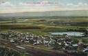
| Community: | Horicon |
|---|---|
| County: | Dodge |
| Historic Name: | |
| Reference Number: | 125741 |

| Date: | 1910 |
|---|---|
| Description: | Elevated view across field towards homes and buildings. |

| Date: | 1891 |
|---|---|
| Description: | Color illustration of the grounds and buildings of the 1893 World's Fair or Columbian Exposition. |
| Date: | 1907 |
|---|---|
| Description: | Caption reads: "Birdseye [sic] View of Cameron Wisconsin." Railroad cars are on railroad tracks between buildings, and houses and what may be the hi... |

| Date: | 1921 |
|---|---|
| Description: | Elevated view of Woodstock, with dwellings, farm buildings and a church. Pastures and fields surround the town. |

| Date: | |
|---|---|
| Description: | Photographic postcard of an elevated view of Kaukauna. There is a water tower in the center, a church on the left, and a smokestack on the right, and the F... |

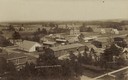
| Date: | 1910 |
|---|---|
| Description: | Elevated view of downtown. Part of the Milwaukee River is on the left side. Sign for the Germania building is in the lower right, and city hall is in the b... |
| Date: | |
|---|---|
| Description: | Elevated view of Cochrane and the surrounding landscape. There are houses, railroad tracks, distant fields, a pond and some irrigation canals. Caption read... |

| Date: | 1870 |
|---|---|
| Description: | Sauk City is the oldest incorporated village in Wisconsin (incorporated in 1854) and also has the oldest organized volunteer fire department in the state, ... |

| Date: | 1974 |
|---|---|
| Description: | This map shows streets, Lake Winnebago, Little Lake Butte Des Morts, and the Fox River. Also included is text on the Fox River Waterways and the history of... |
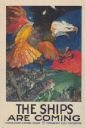
| Date: | 1917 |
|---|---|
| Description: | Poster with an illustration of a bird's-eye view of a large bald eagle flying over a convoy of ships, which are headed towards a fire or explosion over the... |

| Date: | 1870 |
|---|---|
| Description: | Bird's-eye map of Kilbourn City, now known as Wisconsin Dells. Kilbourn City was platted in the 1850s and received a boost when the La Crosse and Milwaukee... |
| Community: | Stevens Point |
|---|---|
| County: | Portage |
| Historic Name: | |
| Reference Number: | 72765 |

| Date: | 1870 |
|---|---|
| Description: | Birds-eye drawing of Oconomowoc depicts street names and street layouts, houses, trees, Oconomowoc River, Fowler Lake, and La Belle Lake. A reference key a... |
If you didn't find the material you searched for, our Library Reference Staff can help.
Call our reference desk at 608-264-6535 or email us at: