 Search: birds
Search: eye
Filter: Subject of botany
Search: birds
Search: eye
Filter: Subject of botany
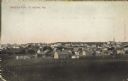
| Date: | 03 17 1909 |
|---|---|
| Description: | Text on front reads: "Birds Eye View, St. Nazianz, Wis." Elevated view of a small town from a field. A church is on the horizon. |

| Date: | 1871 |
|---|---|
| Description: | Birds eye map of New London depicts street names and street locations, houses, trees, the bridge, Wolf River, and the bayou. At the bottom of the map, a re... |

| Date: | |
|---|---|
| Description: | Hand-colored bird's-eye view down the center of a main street in Cedarburg. Horse and buggy traffic is in the street, with dwellings and buildings on the l... |

| Date: | 1867 |
|---|---|
| Description: | Birds-eye drawing of Appleton, Outagamie Co., depicting street names and street layout, houses, the Fox River, the court house, jail, school houses, Lawren... |

| Date: | 1871 |
|---|---|
| Description: | Birds eye map of Monroe, WI, depicts street names and street locations, houses, and trees. A reference key at the bottom of the map shows the locations of ... |

| Date: | 1872 |
|---|---|
| Description: | Birds-eye drawing of Eau Claire depicts street names and street locations, houses, trees, bridges, piers, canals, railroads, and the Chippewa and Eau Clair... |

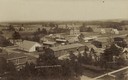
| Date: | 1910 |
|---|---|
| Description: | Elevated view across field towards homes and buildings. |
| Date: | 1907 |
|---|---|
| Description: | Caption reads: "Birdseye [sic] View of Cameron Wisconsin." Railroad cars are on railroad tracks between buildings, and houses and what may be the hi... |

| Date: | 1921 |
|---|---|
| Description: | Elevated view of Woodstock, with dwellings, farm buildings and a church. Pastures and fields surround the town. |

| Date: | |
|---|---|
| Description: | Photographic postcard of an elevated view of Kaukauna. There is a water tower in the center, a church on the left, and a smokestack on the right, and the F... |

| Date: | 1870 |
|---|---|
| Description: | Sauk City is the oldest incorporated village in Wisconsin (incorporated in 1854) and also has the oldest organized volunteer fire department in the state, ... |

| Date: | 1870 |
|---|---|
| Description: | Birds-eye drawing of Oconomowoc depicts street names and street layouts, houses, trees, Oconomowoc River, Fowler Lake, and La Belle Lake. A reference key a... |
| Date: | 1921 |
|---|---|
| Description: | View of Norwalk looking down from a hill. Farm fields and forests surround the town. |
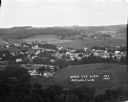
| Date: | 1935 |
|---|---|
| Description: | View from hill of Iron River winding through countryside of farms. |

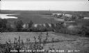
| Date: | 1910 |
|---|---|
| Description: | Slightly elevated view of a town, looking down from a hill across a field, with railroad tracks curving from the right foreground to the left towards the t... |

| Date: | 1972 |
|---|---|
| Description: | Two-color silk screened political poster for George McGovern. An ecology symbol is printed in dark red, and within the symbol is the color orange. Inside t... |

| Date: | 1862 |
|---|---|
| Description: | Birds-eye view of a Wisconsin Civil War regiment on parade in Fond du Lac, as drawn by Louis Kurz from the Marr Street Methodist Church. The regiment canno... |
If you didn't find the material you searched for, our Library Reference Staff can help.
Call our reference desk at 608-264-6535 or email us at: