 Search: Wisconsin
Search: Historical
Filter: Categories of Wisconsin Historical Images
Filter: Subject of attractions
Search: Wisconsin
Search: Historical
Filter: Categories of Wisconsin Historical Images
Filter: Subject of attractions
| Date: | 08 17 1923 |
|---|---|
| Description: | "No flight, no pay." The informal contract between J.A. Smith of Neenah and Roy Larson of Larsen, Wisconsin. Roy Larson established a rural airport in Lar... |

| Date: | 1939 |
|---|---|
| Description: | Back and front covers of the program for the 1939 National Air Races, with a special label acknowledging the role of Harry Bruno as publicist for the Bendi... |

| Date: | 1945 |
|---|---|
| Description: | Totem Pole Room at the Cave of the Mounds. Caption on back of print reads: "The Totem Pole Room is popular with visitors because of the rich coloring and r... |

| Date: | 1948 |
|---|---|
| Description: | A man feeds a bear in a large cage at the Gateway Inn. A group of people are gathered at the right side of the cage. |

| Date: | 1950 |
|---|---|
| Description: | Text on front reads: "Wisconsin Dells, Wis." A model historical village with a guardhouse flying the American flag in the center, flanked by fences and mor... |

| Date: | 09 17 1955 |
|---|---|
| Description: | Vistors entering and exiting the Wisconsin Historical Society Historymobile parked at Point Beach State Park. |
| Date: | 1959 |
|---|---|
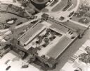
| Description: | An architect's model of Fort Dells. This is not an accurate historical reconstruction, but was built as a tourist attraction. There was never an actual for... |

| Date: | 1966 |
|---|---|
| Description: | This colored road map shows automobile roads in Wisconsin as well as portions of nearby states. Information on the quality and type of any road shown (inte... |

| Date: | 1966 |
|---|---|
| Description: | This colored road map shows automobile roads in Wisconsin as well as portions of nearby states. A map key indicates relative sizes of cities and towns. On ... |

| Date: | 1967 |
|---|---|
| Description: | This colored map published by the State Historical Society of Wisconsin shows key points of interest telling the story of Wisconsin's earliest settlement a... |

| Date: | 1971 |
|---|---|
| Description: | This colored map displays Wisconsin and bordering areas of Iowa, Minnesota, and Michigan. There is color-coding on the map to indicate National Forests, an... |

| Date: | 1973 |
|---|---|
| Description: | This colored map displays Wisconsin and bordering areas of Iowa, Minnesota, and Michigan. There is color-coding on the map to indicate National Forests, a... |

| Date: | 1975 |
|---|---|
| Description: | This colored road map of Wisconsin displays "Featured Points of Interest" and "Historical Points of Interest" in the state, including three color photograp... |

| Date: | 1980 |
|---|---|
| Description: | The general theme of this black and white map is "Discover and Enjoy Wisconsin." The front of the map depicts driving tours numbered 1 through 12; each to... |
| Date: | 08 08 2008 |
|---|---|
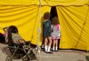
| Description: | Two young girls, with hair curls, look into tent at Irishfest. |

| Date: | 05 |
|---|---|
| Description: | Young woman in a period dress standing at the front entrance of Villa Louis. |

| Date: | |
|---|---|
| Description: | Historical marker identifying the location of the first house in Wisconsin built between Washburn and Ashland in 1658. |
If you didn't find the material you searched for, our Library Reference Staff can help.
Call our reference desk at 608-264-6535 or email us at: