 Search: LIGHTHOUSES
Filter: Reproduction Rights of For Sale
Filter: Subject of industries
Search: LIGHTHOUSES
Filter: Reproduction Rights of For Sale
Filter: Subject of industries

| Date: | 1898 |
|---|---|
| Description: | This 1898 map of Ashland County, Wisconsin, shows the township and range grid, towns, sections, cities and villages, landownership, roads, railroads, swamp... |

| Date: | 1915 |
|---|---|
| Description: | This map of Door County, Wisconsin, from the early 20th century shows roads, schools, churches, creameries and cheese factories, orchards, docks, quarries,... |

| Date: | 1960 |
|---|---|
| Description: | Color photographic postcard view of the Cana Island U.S. Lighthouse surrounded by a green lawn. There is a hand pump near the building. |

| Date: | 1871 |
|---|---|
| Description: | This map shows railroads, canals, towns and some lighthouses. Areas of the company lands proper, tin, iron, gold & silver, silver islet, and lead are color... |
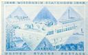
| Date: | 12 13 1947 |
|---|---|
| Description: | Design in blue for Wisconsin Centennial 3 cent postage stamp featuring a badger in a subtle "W" design. |
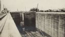
| Date: | 03 1913 |
|---|---|
| Description: | A view looking toward the Atlantic entrance to the Panama Canal, over the Gatun Locks during construction. The entrance lighthouse is seen in the distance.... |
If you didn't find the material you searched for, our Library Reference Staff can help.
Call our reference desk at 608-264-6535 or email us at: