Search: Bureau
Search: of
Filter: Categories of Wisconsin Historical Images
Filter: Subject of transportation
Search: Bureau
Search: of
Filter: Categories of Wisconsin Historical Images
Filter: Subject of transportation
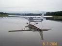
| Date: | 08 02 2001 |
|---|---|
| Description: | A rainy day at Middleton Municipal Airport, formerly the Morey Airfield. |

| Date: | 1930 |
|---|---|
| Description: | A tree-lined, rural road in the Kickapoo Valley of southwestern Wisconsin. |

| Date: | 11 16 2001 |
|---|---|
| Description: | Aerial view of General Mitchell International in Milwaukee, looking southeast to the Lake Michigan shoreline. |
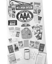
| Date: | 06 23 1939 |
|---|---|
| Description: | Display of travel materials for Wisconsin Division of AAA American Automobile Association Travel Bureau. |
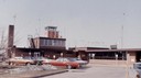
| Date: | 03 31 1971 |
|---|---|
| Description: | The passenger terminal and control tower at the La Crosse Airport. |
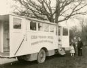
| Date: | 1937 |
|---|---|
| Description: | Wisconsin State Board of Health's vehicle the "Child Welfare Special". |

| Date: | 1935 |
|---|---|
| Description: | This three-part map from the U.S. Bureau of Public Roads identifies highways in Wisconsin that have been improved, indicating those which are federal highw... |
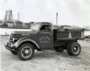
| Date: | 12 01 1937 |
|---|---|
| Description: | A man parking an International D-30 dump truck used by the Bureau of Sewers near a river or harbor. On the opposite shore in the background are buildings, ... |

| Date: | 1939 |
|---|---|
| Description: | This nine-part map from the U.S. Bureau of Public Roads identifies federal and state highways in Wisconsin by pavement type. County, forest, park, and publ... |

| Date: | 12 30 1926 |
|---|---|
| Description: | View across street towards two police trucks parked along the curb near a large brick building. The signs on the side of the trucks reads: "Bureau of Polic... |

| Date: | 02 21 1928 |
|---|---|
| Description: | A man is sitting in the driver's seat of a government truck. The sign painted on the door reads: "Bureau of Fire, Alarm, and Telegraph, F.D.N.Y." |
| Date: | 1915 |
|---|---|
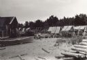
| Description: | Building, boats, and fish net drying reels on South Twin Island in the Apostle Islands archipelago. |

| Date: | 1833 |
|---|---|
| Description: | Map of part of the military road from Fort Crawford to Fort Howard. "Recorded on pages 668.669 Book B." Surveyed by Lieut. Center. Scale: 2 miles = 1 inch. |
| Date: | 1904 |
|---|---|
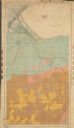
| Description: | This 1904 map from the U.S. Dept. of Agriculture's Bureau of Soils shows the soil types in north-central Douglas County, Wisconsin, and Duluth, Minnesota. ... |
| Date: | |
|---|---|
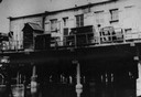
| Description: | View of the bridge over water, with a building behind it. |

| Date: | 1864 |
|---|---|
| Description: | This battlefield map of the Battle of Totopotomoy Creek, also known as the Battle of Bethesda Church, shows the railroads, roads, vegetation and topography... |
If you didn't find the material you searched for, our Library Reference Staff can help.
Call our reference desk at 608-264-6535 or email us at: