 Search: Bureau
Search: of
Filter: Categories of Wisconsin Historical Images
Filter: Subject of fortification
Search: Bureau
Search: of
Filter: Categories of Wisconsin Historical Images
Filter: Subject of fortification

| Date: | 1833 |
|---|---|
| Description: | Map of part of the military road from Fort Crawford to Fort Howard. "Recorded on pages 668.669 Book B." Surveyed by Lieut. Center. Scale: 2 miles = 1 inch. |
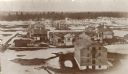
| Date: | 1865 |
|---|---|
| Description: | Elevated view of the fort, with snow on the ground. |
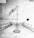
| Date: | |
|---|---|
| Description: | View of the parade grounds surrounded by possibly the barracks. An American flag on a pole dominates the image. |
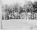
| Date: | 1900 |
|---|---|
| Description: | A group of men posing together in front of a stand of trees. Caption reads: "Indian 'Sun Dance' near Fort Washakie, Wyo, 1900." |

| Date: | 1835 |
|---|---|
| Description: | Little Lake Butte Des Morts just north of Lake Winnebago where Governor Lewis Cass of Michigan, and Thomas McKenney, head of the Bureau of Indian Affairs (... |

| Date: | 1816 |
|---|---|
| Description: | This is a photostat copy of a manuscript map in the National Archives showing a plan of Fort Howard and a view of its north side. Originally surveyed by Wi... |

| Date: | 1864 |
|---|---|
| Description: | This map created during the Civil War indicates Confederate fortifications, houses, names of residents, towns, roads, railroads, relief by hachures, draina... |

| Date: | 1818 |
|---|---|
| Description: | Overhead view of the layout of the fort, with the Fox River at the top, and a "Cranberry Marsh of 1/2 mile in extent" below right. At the bottom is a rende... |

| Date: | 1862 |
|---|---|
| Description: | This map shows landownership on a military reserve, private claims, buildings (including Fort Howard and U.S. sawmill), swamps, public barns and fields, an... |
If you didn't find the material you searched for, our Library Reference Staff can help.
Call our reference desk at 608-264-6535 or email us at: