 Search: A.
Search: Lapham
Filter: Categories of Wisconsin Historical Images
Filter: Community of Milwaukee
Search: A.
Search: Lapham
Filter: Categories of Wisconsin Historical Images
Filter: Community of Milwaukee
| Date: | 1868 |
|---|---|
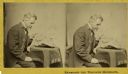
| Description: | Stereograph of Increase Lapham examining a fragment of a meteorite. |
| Date: | 1900 |
|---|---|
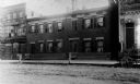
| Description: | Exterior view of the home of Increase A. Lapham at 321-325 Poplar Street, which was built by J.A. Messenger in 1848. |

| Date: | |
|---|---|
| Description: | Map showing Indian mounds in Milwaukee's Second Ward from a sketch made by Increase Lapham in 1836. Streets shown on the map include 6th Street, 5th Street... |
| Date: | |
|---|---|
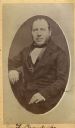
| Description: | Carte-de-visite portrait of Franz Brandecke, Milwaukee-based geologist. Worked on Wisconsin geological survey with Lapham. Handwritten text on front read... |

| Date: | |
|---|---|
| Description: | Letterhead stationery featuring an engraving of the Milwaukee Iron Company foundry. The letter is from an officer of the company to noted geologist Increas... |
| Date: | 1870 |
|---|---|
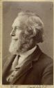
| Description: | Carte-de-visite portrait of William H. Canfield (1819-1913), a Wisconsin civil engineer and surveyor who is best known for his studies of Sauk County's nat... |
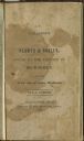
| Date: | 1836 |
|---|---|
| Description: | Title page of Increase Lapham's A catalog of Plants & Shells, Found in the vicinity of Milwaukee on the West Side of Lake Michigan, |

| Date: | 08 20 1964 |
|---|---|
| Description: | View of Mr. and Mrs. Paul Washington, standing on the sidewalk in the foreground with their backs to the camera, who were the first tenants of the Lapham P... |
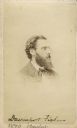
| Date: | 1870 |
|---|---|
| Description: | Vignetted carte-de-visite portrait of Professor Davenport Fisher (1832-1911), Milwaukee chemist. After earning his Ph.D. in Chemistry from Heidelberg Unive... |
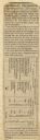
| Date: | 07 22 1837 |
|---|---|
| Description: | Table printed in Milwaukee Advertiser indicating the time of flowering of several wild plants at Milwaukee and near the head of the Pishtaka River. |

| Date: | 1849 |
|---|---|
| Description: | A hand-drawn map of showing the two proposed routes from the Milwaukee River to the Moody’s Lime Quarry at Milwaukee, Wisconsin. The map includes the route... |
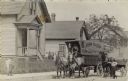
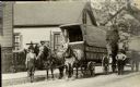
| Date: | |
|---|---|
| Description: | View from the street of John Hahn standing on the right with a horse hitched to a passenger wagon. In the center is the furniture moving wagon he owns, in ... |

| Date: | 05 05 1955 |
|---|---|
| Description: | A young man is standing and smiling and looking at a woman sitting on the left, while another young man sitting on the right is looking on. In front of the... |

| Date: | 1869 |
|---|---|
| Description: | This map shows lot and block numbers, some property ownership, wards, roads, and railroads and includes inset map of Glidden & Lockwood’s addition. There a... |

| Date: | 1838 |
|---|---|
| Description: | A map of the proposed route of the Milwaukee and Rock River Canal from Fort Atkinson on the Rock River in the west to the city of Milwaukee and Lake Michig... |

| Date: | 1855 |
|---|---|
| Description: | Pen-and-ink on paper. Includes certifications signed by surveyor and by "John T. Perkins, by his attorney I.A. Lapham." Inscribed and signed certification ... |

| Date: | 1845 |
|---|---|
| Description: | Map of Wisconsin, including lower western border with Iowa, southern border along Illinois, eastern shoreline of Lake Michigan, and northern area along Wis... |
| Date: | |
|---|---|
| Description: | John Hahn stands in the street near his horse-drawn cart. The side of the cart says 'John Hahn Piano & Furniture Moving'. The cart, John Hahn, and the cart... |
If you didn't find the material you searched for, our Library Reference Staff can help.
Call our reference desk at 608-264-6535 or email us at: