 Filter: Subject of iroquois indians
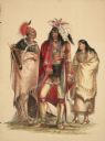
| Date: | 1844 |
|---|---|
| Description: | Portrait of North American Indians (Plate 1). "The group in Plate No. 1 is composed of three Portraits from my collection, representing three different t... |
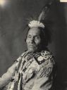
| Date: | 12 1901 |
|---|---|
| Description: | Portrait (Profile) of Hodjiage-De (Fish Carrier) or (He Bears A Fish by The Forehead Strap), called William Henry Fishcarrier, in native dress with headdre... |
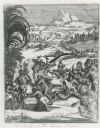
| Date: | |
|---|---|
| Description: | Illustration from Hennepin's "A New Discovery of a Vast Country in America". The illustration is titled "The Cruelty of The Savage Iroquois". |

| Date: | 1905 |
|---|---|
| Description: | This pictorial representation of part of Lake Winnebago and the Fox River in 1703, showing interactions between white beaver hunters and the Iroquois is ta... |

| Explorer and Trader |
|---|
| Biography of Daniel Greysolon Sieur Duluth who helped protect the Wisconsin area against raids of the Iroquois. |
| Brief rundown of the events surrounding the series of confrontations between the Meskwaki (Fox) Indians and French, largely fought between 1712 and 1730. |
| French Official, Captain and Fur Trader |
|---|
| Biography of French Official, Captain and Fur Trader Paul Marin. |
| A Priest Follows Another Priest's 300-Year-Old Path to Death |
|---|
| Learn how Rev. A. A. A. Schmirler traced the path Fr. Rene Menard took in 1661 down northern Wisconsin's rivers to the likely spot of his death. |
| A Frenchman's Disastrous Expedition |
|---|
| Learn about explorer Robert de La Salle's iron-handed chief lieutenant, Henri de Tonty, and what resulted in the worst winter of his life. |
| New Tribes Brought to Wisconsin by French Commerce |
|---|
| Learn how contact with Europeans, the fur trade and warfare among their tribes drove many Indians to the Wisconsin territory in the 17th century. |
| Read an account of the French explorer who claimed much of Wisconsin for France and who traded with several Indian tribes near Green Bay, Wisconsin. |
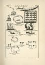
| Date: | |
|---|---|
| Description: | An illustration depicting various aspects of Indian life, including dancing, a sweat lodge, cooking, and burial of the dead. Indians are referred to as "sa... |

| Date: | 1720 |
|---|---|
| Description: | One of Herman Moll's most famous maps, often referred to as The Beaver Map for its elaborate engraved inset depicting and describing beavers building a dam... |

| Date: | 1720 |
|---|---|
| Description: | This map of North America shows cities, rivers, lakes, and a few topographical features, complete with numerous descriptive blocks of text about expedition... |

| Date: | 1757 |
|---|---|
| Description: | This map shows the cities, plantations, lakes, rivers, mountains, Native American territories and colonial borders of the Eastern half of North America, pl... |

| Date: | 1758 |
|---|---|
| Description: | This detailed map of north eastern America shows the boundaries, cities, mountains, rivers, lakes, Native American land and towns, and roads from east of t... |

| Date: | 1777 |
|---|---|
| Description: | This detailed map of the American colonies shows cities, villages, roads, mountains, lakes, rivers, swamps, counties, state boundaries, and Native American... |

| Date: | 1776 |
|---|---|
| Description: | Map of New Jersey and New York, showing cities, forts, roads, counties, townships, land grants, rivers, lakes and several topographical features. Much of t... |

| Date: | 1636 |
|---|---|
| Description: | Map of North America, divided into regions, and showing some rivers, lakes, settlements, cities, mountains, and Native American land. Of the Great Lakes on... |
If you didn't find the material you searched for, our Library Reference Staff can help.
Call our reference desk at 608-264-6535 or email us at: