 Filter: Subject of Water
Filter: Community of Madison
Filter: Subject of Water
Filter: Community of Madison

| Date: | 1949 |
|---|---|
| Description: | Color bird's-eye map of the University of Wisconsin-Madison as it was midcentury, with two co-eds, several photographs of campus landmarks around edges, an... |
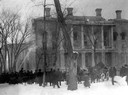
| Date: | 02 27 1904 |
|---|---|
| Description: | Wisconsin State Capitol fire, showing a crowd watching near the South Wing. Some of the contents of the building are already in wagons ready to be hauled a... |

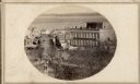
| Date: | 1857 |
|---|---|
| Description: | Bird's-eye view of Madison over rooftop and across lake with sailboats and steamers. A group of people are standing on a viewing platform on the roof in th... |
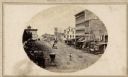
| Date: | 1873 |
|---|---|
| Description: | Elevated view of South Pinckney Street from the Wisconsin State Capitol, with East Washington Avenue to the left and Lake Monona on the distant right. The ... |
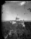
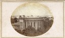
| Date: | |
|---|---|
| Description: | Elevated view of the third Wisconsin Capitol as originally constructed. The trees of the Capitol Park are already so large that they largely obscure any vi... |
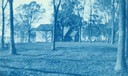
| Date: | 1900 |
|---|---|
| Description: | Cyanotype print of Winnequah on Lake Monona with small buildings and three platforms for swings. A note on the back of the print reads: "The high swing was... |

| Date: | 1929 |
|---|---|
| Description: | Bird's-eye map of the University of Wisconsin-Madison on Lake Mendota. Black and white drawing with named streets and numbered buildings without location ... |
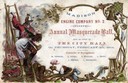
| Date: | 02 04 1864 |
|---|---|
| Description: | Embossed invitation to the fourth masquerade ball of the Madison Fire Engine Company #2. The invitation depicts a fire fighter on a ladder carrying a woman... |
| Date: | 1861 |
|---|---|
| Description: | East (King Street) wing of the third Wisconsin State Capitol and the south wall of the Territorial Capitol (at the left) taken from the roof of the buildin... |
| Date: | 1860 |
|---|---|
| Description: | Intersection of King and East Main streets photographed by John S. Fuller from the Wisconsin State Capitol roof, about 1860-1863. In the foreground two st... |

| Date: | 1855 |
|---|---|
| Description: | Part of George Harrison's "Map of the City of Madison," showing the development of the isthmus and the small size of the second Capitol (54' x 104') in com... |

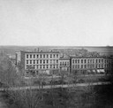
| Date: | 1896 |
|---|---|
| Description: | A portion of John B. Heim's map of the Water Works System of Madison showing the size of the third Wisconsin Capitol (228' x 226') in comparison with the C... |
| Date: | |
|---|---|
| Description: | View of Pinckney Street, about 1860, from the roof of the Fairchild Block at the corner of East Main and South Pinckney looking northwest toward Lake Mendo... |
| Date: | 1898 |
|---|---|
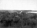
| Description: | Elevated view of Observatory Hill, Observatory Hall, the Agriculture Campus and Lake Mendota on the University of Wisconsin-Madison Campus. |
| Date: | 03 30 1889 |
|---|---|
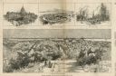
| Description: | Bird's-eye view from Bascom Hill of Madison, with vignettes of the Wisconsin State Capitol, Lake Monona, and the Capitol Park. |
| Date: | 1926 |
|---|---|
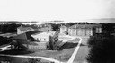
| Description: | View of Adams, Tripp and Van Hise Halls. All are residence halls on the University of Wisconsin campus with Picnic Point and Lake Mendota in the backgroun... |

| Date: | 1945 |
|---|---|
| Description: | View of the lower campus of the University of Wisconsin-Madison includes Bascom Hill, Wisconsin Historical Society, Memorial Union and the Armory (Red Gym ... |

| Date: | 1945 |
|---|---|
| Description: | Aerial view of Bascom Hill, Bascom Hall, Wisconsin Historical Society on the University of Wisconsin Madison campus with Lake Mendota on the right. |
| Date: | 1923 |
|---|---|
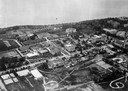
| Description: | Aerial view of the University of Wisconsin campus shows from west to east the Agricultural Hall, Observatory Hall and the Wisconsin Historical Society with... |

| Date: | 1926 |
|---|---|
| Description: | Originally titled 'Recent Aeroplane View of University Campus', the view of the Wisconsin Historical Society, the Red Gym, Science Hall and Bascom Hall wit... |
If you didn't find the material you searched for, our Library Reference Staff can help.
Call our reference desk at 608-264-6535 or email us at: