 Filter: Subject of Voyages and travels
Filter: Subject of maps
Filter: Subject of Voyages and travels
Filter: Subject of maps

| Combine geography and map skills with reading, math, and problem-solving in this lesson plan |
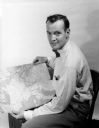
| Date: | 08 31 1953 |
|---|---|
| Description: | Arthur Constable displays the route of his 10-month travel route through Europe and North Africa on a map. |

| Date: | 02 1823 |
|---|---|
| Description: | A map featuring the North American expedition from Pittsburgh to the Rocky Mountains led by Edwin James. |

| Date: | 1788 |
|---|---|
| Description: | This map shows the north western coast of North America, including the southern coast of what will be Alaska and parts of the Aleutian Islands. It includes... |

| Date: | 1769 |
|---|---|
| Description: | Double hemispherical map showing the continents, islands, countries, and a few major cities of the world. The routes of a few explorers are depicted and la... |

| Date: | 1679 |
|---|---|
| Description: | Decorative and detailed map of the eastern half of North America. Regions, cities, colonies, Native America land, rivers, lakes and some nautical features ... |

| Date: | 1724 |
|---|---|
| Description: | Map showing the mountains, rivers, lakes, settlements, islands, and regions of North and South America. Characteristic of de L'Isle, this map is highly det... |

| Date: | 1684 |
|---|---|
| Description: | Map of North America showing some colonies, cities, rivers, lakes, and Native American land. Ship routes spread across both oceans, including one decorated... |

| Date: | 1713 |
|---|---|
| Description: | Map showing the regions explored by Robert de La Salle between 1681 and 1686, as well as the route La Salle, and later Henri Joutel, took, moving north fro... |

| Date: | 1775 |
|---|---|
| Description: | This six sheet large format map is one of the most informative maps of its time. It shows cities, Native American land, lakes, rivers, mountains, topograph... |

| Date: | 1777 |
|---|---|
| Description: | This important map highlights the frantic desire and search for the north west passage. It shows a few settlements and mountains in Russia, north west Amer... |
| Date: | 1910 |
|---|---|
| Description: | Carl Greene's drawing of a map of The Gang's trip to Winton, titled "We drive to Winton." This map shows a road currently known as the Thirteen Corners Roa... |
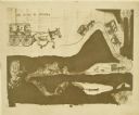
| Date: | 1910 |
|---|---|
| Description: | The Gang is sitting on their packs or bedrolls as they consult their maps with a ranger. |
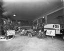
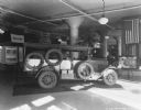
| Date: | 02 07 1929 |
|---|---|
| Description: | The Sahara truck on display with information panels. Other vehicles are on display in the large room. |
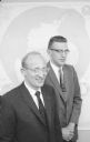
| Date: | 06 12 1958 |
|---|---|
| Description: | Antarctic explorers Dr. Edward Thiel (left) and John Behrendt (right) recently returned from a year long stay in Antarctica. Dr. Thiel was the co-leader of... |
| Date: | 03 18 1929 |
|---|---|
| Description: | "The Truck that Crossed the Sahara" on display in a showroom. |
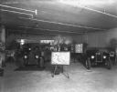
| Date: | 03 26 1929 |
|---|---|
| Description: | "Truck That Crossed The Sahara" is on display in a dealership. In the foreground is a map on an easel. |
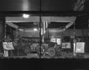
| Date: | 04 06 1929 |
|---|---|
| Description: | View through a show window of a display of the truck that crossed the Sahara. There is a map on an easel on the left. A poster on an easel on the right has... |
| Date: | 04 05 1929 |
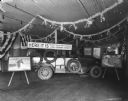
|---|---|
| Description: | View of a display of the truck that crossed the Sahara. Banners and flags are hanging around the room. A sign above the trucks reads: "Here It Is! The Truc... |
If you didn't find the material you searched for, our Library Reference Staff can help.
Call our reference desk at 608-264-6535 or email us at: