Filter: FULL_DATE of 1868
Filter: Subject of water
Filter: FULL_DATE of 1868
Filter: Subject of water

| Date: | 1868 |
|---|---|
| Description: | The sidewheel packet, Keokuk, loaded with passengers beside a barge at a landing. The landing is filled with people and horse-drawn vehicles. The si... |

| Date: | 1868 |
|---|---|
| Description: | This 1868 birds-eye view depicts the buildings, streets, railroad, vegetation and topography of Columbus, Wisconsin. The high school, cemetery, railroad de... |

| Date: | 1868 |
|---|---|
| Description: | Bird's-eye map of Portage, with insets of the Court House and the Public School. |

| Date: | 1868 |
|---|---|
| Description: | Bird's-eye map of Manitowoc, with four insets. Manitowoc County. |
| Date: | 1868 |
|---|---|
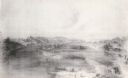
| Description: | View of the Baraboo River and surrounding structures. |

| Date: | 1868 |
|---|---|
| Description: | Elevated view up Wisconsin Avenue showing City Hall on the corner at Mifflin Street on the left, with the Post Office to the right. Further down is the Pre... |

| Date: | 1868 |
|---|---|
| Description: | Showing the counties, towns and railroads. Partly colored. Scale: 1 inch = 20 miles. |
| Date: | 1868 |
|---|---|
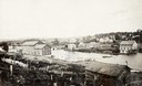
| Description: | A view taken from the elevation on the south side of the Mullet River. |

| Date: | 1868 |
|---|---|
| Description: | Stereograph of an elevated view of the Vilas House hotel, East Main Street at Monona Avenue. |

| Date: | 1868 |
|---|---|
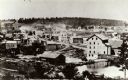
| Description: | Elevated view over rooftops looking towards Lake Michigan shoreline. Seaman's Furniture and Rooms building is surrounded by other commercial buildings. The... |
| Date: | 1868 |
|---|---|
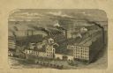
| Description: | Engraved illustration of an elevated view of the "McCormick Reaper & Mower Works." Ships are on Lake Michigan in the background. |

| Date: | 1868 |
|---|---|
| Description: | The river steamer Chippewa drawn up alongside shore on the West Eau Claire Levee. The steamer was built by Captain E.E. Heerman at La Crosse in 1866... |

| Date: | 1868 |
|---|---|
| Description: | Wisconsin and parts of Michigan, Minnesota, Illinois and Iowa. It shows cities and towns, drainage, administrative boundaries and the railroad network with... |

| Date: | 1868 |
|---|---|
| Description: | This map of the entire state shows county boundaries outlined in red, cities of over 3000 inhabitants and county seats. It also marks rivers, lakes, railro... |

| Date: | 1868 |
|---|---|
| Description: | Prepared for the State Board of Emigration in 1868, this map shows county boundaries, some cities, and completed and projected railroads. |

| Date: | 1868 |
|---|---|
| Description: | A detailed, cloth mounted map of Grant County that shows the townships, towns, roads, completed and under construction railroads, cemeteries, mills, lead m... |

| Date: | 1868 |
|---|---|
| Description: | Map showing the northern water routes between Mississippi River and Atlantic Ocean Relief shown by hachures. Includes Profile of the Erie Canal, table of ... |

| Date: | 1868 |
|---|---|
| Description: | This map shows land ownership by name, lots, roads, railroads, and part of the Fox River. The map includes an explanation and table of witnesses to the cor... |

| Date: | 1868 |
|---|---|
| Description: | This map of the state of Wisconsin was created in 1868 and later used by Increase Lapham to trace an outbreak of tornadoes going across the state in May of... |
If you didn't find the material you searched for, our Library Reference Staff can help.
Call our reference desk at 608-264-6535 or email us at: