 Filter: Community of Montfort
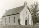
| Date: | 1930 |
|---|---|
| Description: | A church in Montfort; the parson was Reverend Ebenezer Williams. |
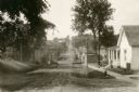
| Date: | 1928 |
|---|---|
| Description: | View down dirt road. Houses are on the right. Further down the road are commercial buildings and automobiles. |
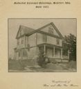
| Date: | |
|---|---|
| Description: | Methodist Episcopal Parsonage, built in 1905. Caption on print at top reads: "Methodist Episcopal Parsonage, Montfort, Wis. Built 1905." Caption at bottom:... |
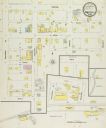
| Date: | 12 1899 |
|---|---|
| Description: | Sanborn map of Montfort, population 800. |
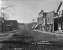
| Date: | 1909 |
|---|---|
| Description: | View from unpaved street of a business district. W.G. Baxter's dry goods store is on the corner, and next to it is the Opera House. A number of people are ... |
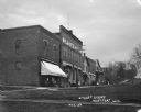
| Date: | 1911 |
|---|---|
| Description: | View down an unpaved street in the business district. The buildings along the street include: a pool room, restaurant, opera house, W.G. Baxter's dry goods... |
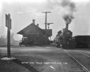
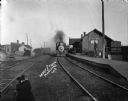
| Date: | 1926 |
|---|---|
| Description: | View across road along railroad tracks of a train departing the Montfort depot. Two cars are parked at the depot, and a number of people are on the platfor... |
| Date: | 1924 |
|---|---|
| Description: | View across railroad tracks of storefronts located near the train depot. The shops include: Montford Lumber Company, Damerow's Cafe, and the American Hotel... |
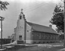
| Date: | 1926 |
|---|---|
| Description: | Exterior of Saint Thomas Church. The brick building features a steeple, arched windows, and double doors. A plaque on the front says: "St. Thomas 1925." |

| Date: | 1928 |
|---|---|
| Description: | Shows different types of roads, railroads, schools, churches, farmsteads, cheese factories, mine shafts, old surface workings, streams, old sulphur pits, a... |

| Date: | 1848 |
|---|---|
| Description: | Pen-and-ink on paper. Includes certifications signed by "Geo R. Bluntz, District Survey of Grant Co. W.T." and Ben C. Eastman. |
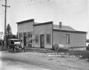
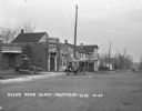
| Date: | 1925 |
|---|---|
| Description: | View across road towards Chaney's Cash General Store. Behind trees on the left is a house and windmill. Laundry is drying behind the store on the right. A ... |
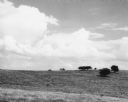
| Date: | 06 30 1955 |
|---|---|
| Description: | From caption: "Prairie two miles north of Montfort Wis on the Iowa-Grant County line trunk highway I view to the east from the road. Photo by Robert Hall 1... |
| Date: | |
|---|---|
| Description: | A locomotive is moving along the tracks along the platform at the depot in Montfort. A man is standing near carts on the right at the end of the platform, ... |

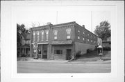
| Community: | Montfort |
|---|---|
| County: | Grant |
| Historic Name: | |
| Reference Number: | 45514 |
| Community: | Montfort |
|---|---|
| County: | Grant |
| Historic Name: | |
| Reference Number: | 45515 |

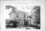
| Community: | Montfort |
|---|---|
| County: | Grant |
| Historic Name: | Fountain Inn |
| Reference Number: | 45516 |
| Community: | Montfort |
|---|---|
| County: | Grant |
| Historic Name: | |
| Reference Number: | 45517 |
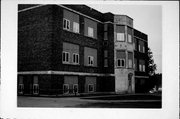
| Community: | Montfort |
|---|---|
| County: | Grant |
| Historic Name: | |
| Reference Number: | 45519 |
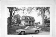
| Community: | Montfort |
|---|---|
| County: | Grant |
| Historic Name: | |
| Reference Number: | 45521 |
If you didn't find the material you searched for, our Library Reference Staff can help.
Call our reference desk at 608-264-6535 or email us at: