 Filter: Categories of Wisconsin Historical Images
Filter: State of Virginia
Filter: Subject of battlefields
Filter: Categories of Wisconsin Historical Images
Filter: State of Virginia
Filter: Subject of battlefields
| Date: | |
|---|---|
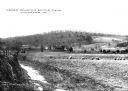
| Description: | A view of the Cedar Mountain Battlefield. Caption reads: "Cedar Mountain Battle Field, Culpeper, VA." |
| Date: | |
|---|---|
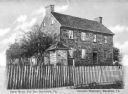
| Description: | A fence surrounds an old stone house and trees at Bull Run Battlefield. Caption reads: "Stone House, Bull Run Battlefield, Va." |

| Date: | |
|---|---|
| Description: | A painting of 'The Charge of the New Market Cadets' by West Clinedinst (Clinedienst). The work commemorates the Battle of New Market that took place on May... |
| Date: | |
|---|---|
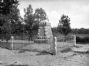
| Description: | View of a monument to New Jersey's Fifteenth Regiment on the site of a battlefield. The memorial was erected by the State of New Jersey and is surrounded b... |
| Date: | |
|---|---|
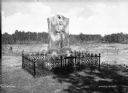
| Description: | View of a monument on a battlefield to Major General John Sedgwick, killed in action on May 9, 1864. The memorial, erected in 1887 by veterans of Segdwick'... |
| Date: | |
|---|---|
| Description: | A view of monuments in a cemetery that stand on the ground of a once bloody battlefield. The monument of the left commemorates New York's 49th Infantry, an... |

| Date: | 1861 |
|---|---|
| Description: | This map shows Manassas during the First Battle of Bull Run, in which the 2nd Wisconsin Infantry fought, and the Leesburg area, the site of the Battle of B... |

| Date: | 1862 |
|---|---|
| Description: | This map illustrates the official plan for the siege of Yorktown, Virginia, and indicates the headquarters of Generals McClellan, Porter, Woodbury, and Hei... |

| Date: | 1862 |
|---|---|
| Description: | This map shows the region of southeastern Virginia which served as the setting for the Peninsular Campaign of 1862. A few battle sites are marked by crosse... |

| Date: | 1862 |
|---|---|
| Description: | This pen and ink drawing of the First Battle of Bull Run, JuIy 21st, 1861, was made by Charles K. Dean, adjutant with the 2nd Wisconsin Infantry. The 2nd W... |

| Date: | 1864 |
|---|---|
| Description: | This map of the battlefield on the North Anna River at Hanover Junction illustrates the Union positions in blue and Confederate positions in red. Roads, ra... |

| Date: | 1864 |
|---|---|
| Description: | This colored map shows cities, rail lines, and geographic features in eastern Virginia. Circles around Richmond at 10 mile intervals indicate distances fro... |

| Date: | 1864 |
|---|---|
| Description: | This map of the battlefield at Wilderness, Virginia, illustrates the Union positions in blue and Confederate positions in red. Roads, railroads, vegetation... |

| Date: | 1864 |
|---|---|
| Description: | This battlefield map of the Battle of Totopotomoy Creek, also known as the Battle of Bethesda Church, shows the railroads, roads, vegetation and topography... |

| Date: | 1864 |
|---|---|
| Description: | This battlefield map of the Battle of Totopotomoy Creek, also known as the Battle of Bethesda Church, shows the railroads, roads, vegetation and topography... |

| Date: | 1864 |
|---|---|
| Description: | This map of the area of the First Battle of Bull Run shows military positions and troop movements as well as the names of landowners, vegetation and land u... |

| Date: | 1865 |
|---|---|
| Description: | This map of the battlefield at Spotsylvania Courthouse illustrates the Union positions in blue and Confederate positions in red. Roads, railroads, vegetati... |

| Date: | 1865 |
|---|---|
| Description: | This map of the battlefield at Five Forks, Va., shows Union and Confederate positions, roads, drainage, vegetation, relief by hachures, and names of reside... |

| Date: | 1865 |
|---|---|
| Description: | Map extends from Harper's Ferry in the north to Petersburg in the south and from Lexington east to Heathsville. The routes of the II, V, VI, IX, XVIII, and... |

| Date: | 1865 |
|---|---|
| Description: | This detailed map of the area between Richmond and Petersburg shows fortifications, roads, railroads, towns, street patterns of Petersburg and Richmond, dr... |
If you didn't find the material you searched for, our Library Reference Staff can help.
Call our reference desk at 608-264-6535 or email us at: