 Filter: Categories of Wisconsin Historical Images
Filter: State of Pennsylvania
Filter: Subject of transportation
Filter: Year of 1800-1899
Filter: Categories of Wisconsin Historical Images
Filter: State of Pennsylvania
Filter: Subject of transportation
Filter: Year of 1800-1899
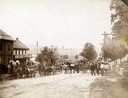
| Date: | 1899 |
|---|---|
| Description: | Families and citizens with horse-drawn wagons gathered in a small town for delivery of McCormick farm machines from General Agent Daniel Klinedinst. Horses... |
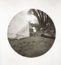
| Date: | 05 06 1894 |
|---|---|
| Description: | Setting up camp on a bank of the Youghiogheny River. William Turville holds a canvas bag of bedding, while Jessie hands her son Fredrik a satchel from the ... |

| Date: | 1850 |
|---|---|
| Description: | [... through northern United States from New York to Minnesota]. Lithography by T. Sinclair. From Perrault papers, Lucien S. Hanks, donor. |

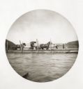
| Date: | 1894 |
|---|---|
| Description: | Panoramic view of Rochester and the Beaver Valley. Junction of the Beaver River and the Ohio River. Settlements and multiple bridges are in the background. |
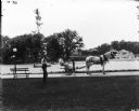
| Date: | 1899 |
|---|---|
| Description: | A male grounds keeper is driving a horse-drawn mower down a path on a park or estate grounds. Another man is leaning against a slender tree. Both men are w... |
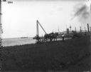
| Date: | 1899 |
|---|---|
| Description: | A man in work clothes is operating a horse-drawn mower in a patch of grass along a waterfront, while another man wearing a hat and tie is looking on. Ships... |
| Date: | 05 06 1894 |
|---|---|
| Description: | View of a traveling junk boat near the shoreline on the Youghiogheny River. There is a bridge in the background. |
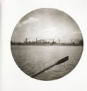
| Date: | 05 06 1894 |
|---|---|
| Description: | View from the Monongahela River of the Edgar W. Thompson steel works. An oar from Thwaites' boat is visible in the foreground. |
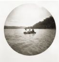
| Date: | 05 06 1894 |
|---|---|
| Description: | Three boys in a crude boat on the Monongahela River. |
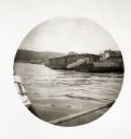
| Date: | 05 06 1894 |
|---|---|
| Description: | View on the Monongahela River of a ferry with passengers and horse-drawn carriages. There is a bridge in the background. |

| Date: | 05 07 1894 |
|---|---|
| Description: | View of a houseboat named "Two Doves" on the Ohio River. |

| Date: | 05 08 1894 |
|---|---|
| Description: | A man transports nitroglycerin in a boat which has a red danger flag at the bow (unseen against the dark background). |
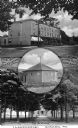
| Date: | 1890 |
|---|---|
| Description: | Composite image combining Girard, Pennsylvania landmarks. At the top is "The Old Keystone," in the center is "The Dan Rice Ring Barn," and at the bottom is... |

| Date: | 1860 |
|---|---|
| Description: | View of an old cabin, built in 1860, on the grounds of the Bedford Springs Hotel. In the foreground is a dirt road, and a pedestrian is walking near the fe... |
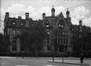
| Date: | 1881 |
|---|---|
| Description: | A view of Logan Hall, home to the Wharton School of Business. The building features Gothic Revival elements, including the arched windows and quatrefoils f... |

| Date: | 1876 |
|---|---|
| Description: | Detailed topographic map of the Gettysburg battlefield created thirteen years after the battle. This map shows day one of the battle. The map shows drainag... |

| Date: | 1863 |
|---|---|
| Description: | These detailed topographical maps of the Battle of Gettysburg show drainage, vegetation, roads, railroads, fences, houses with names of residents, and a de... |

| Date: | 1863 |
|---|---|
| Description: | These detailed topographical maps of the Battle of Gettysburg show drainage, vegetation, roads, railroads, fences, houses with names of residents, and a de... |

| Date: | 1863 |
|---|---|
| Description: | These detailed topographical maps of the Battle of Gettysburg show drainage, vegetation, roads, railroads, fences, houses with names of residents, and a de... |

| Date: | 1863 |
|---|---|
| Description: | This map shows drainage, vegetation, roads, railroads, fences, dwellings with names of inhabitants, and land owned by the United States. Union and Confeder... |
If you didn't find the material you searched for, our Library Reference Staff can help.
Call our reference desk at 608-264-6535 or email us at: