 Filter: Categories of Wisconsin Historical Images
Filter: State of New York
Filter: Subject of ships
Filter: Subject of land
Filter: Categories of Wisconsin Historical Images
Filter: State of New York
Filter: Subject of ships
Filter: Subject of land

| Date: | 1901 |
|---|---|
| Description: | A man is standing on the deck of a large ship as it travels the Hudson River. Other passengers are sitting on benches in the background. |
| Date: | |
|---|---|
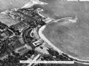
| Description: | Bird's eye view of Playland, part of the Westchester Co. Park System. View features the park, the shoreline, the ocean, and several ships docked along the ... |

| Date: | 10 19 1933 |
|---|---|
| Description: | "A Night Above the Clouds" dinner menu, with a tipped-in infra-red photograph of the peaks around Mt. Everest on cream stock embedded with silver flecks. O... |

| Date: | 10 1776 |
|---|---|
| Description: | Broadside map showing the British invasion of New York city in August and September of 1776. The map shows important cities, forts, roads, hills, mountains... |

| Date: | 02 1777 |
|---|---|
| Description: | Map depicting the campaigns of October and November 1776, in Manhattan, Westchester, and part of New Jersey, published only a few months after the conclusi... |

| Date: | 03 1777 |
|---|---|
| Description: | Map showing the British and Hessian attack on Fort Washington in November of 1776. The movements and fortifications of the British and Hessian troops appea... |
If you didn't find the material you searched for, our Library Reference Staff can help.
Call our reference desk at 608-264-6535 or email us at: