 Filter: Categories of Wisconsin Historical Images
Filter: State of New York
Filter: Subject of revolution, 1775-1783
Filter: Categories of Wisconsin Historical Images
Filter: State of New York
Filter: Subject of revolution, 1775-1783
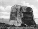
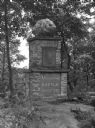
| Date: | 1913 |
|---|---|
| Description: | A monumental rock dedicated to Nathan Hale (1755-1776), schoolteacher, member of the Continental Army during the American Revolutionary war and widely rega... |
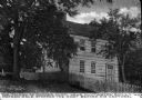
| Date: | |
|---|---|
| Description: | The Mother Chick Tavern, where Nathan Hale, widely considered America's first spy during the American Revolutionary War, stopped the night before his captu... |
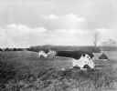
| Date: | |
|---|---|
| Description: | A view of two cannons on a battlefield at Fort St. George, in which a battle broke out on November, 23, 1780. |
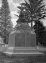
| Date: | |
|---|---|
| Description: | View of a Revolutionary War Memorial, erected by Mrs. Nancy M. Parke in 1903. A liberty bell and eagle sit atop a list of soldiers of the war in 1776. |
| Date: | |
|---|---|
| Description: | View of a monument to the Minisink Battle. The plaque reads, "Erected by the Historical Societies of the Minisink Country and of the State of New York on t... |

| Date: | 1777 |
|---|---|
| Description: | Map showing the Hudson River in three sections, from New York City up through Lake Champlain, including cities, forts, roads, topographical features, and n... |

| Date: | 1795 |
|---|---|
| Description: | Detailed map of New York, showing counties, cities, mines, mills, roads, swamps, mountains, lakes and rivers. The map also shows Native American towns and ... |

| Date: | 1778 |
|---|---|
| Description: | Map of the land between Fort Ticonderoga and Albany. It shows cities, forts, mills, roads, mountains, swamps, waterfalls, lakes, and rivers. A few annotati... |

| Date: | 10 1776 |
|---|---|
| Description: | Broadside map showing the British invasion of New York city in August and September of 1776. The map shows important cities, forts, roads, hills, mountains... |

| Date: | 02 1777 |
|---|---|
| Description: | Map depicting the campaigns of October and November 1776, in Manhattan, Westchester, and part of New Jersey, published only a few months after the conclusi... |

| Date: | 03 1777 |
|---|---|
| Description: | Map showing the British and Hessian attack on Fort Washington in November of 1776. The movements and fortifications of the British and Hessian troops appea... |

| Date: | 11 1781 |
|---|---|
| Description: | Map of New York, Staten Island, and Long Island, showing the placements of forts, and the movement of troops in 1776. The map also includes towns, cities, ... |

| Date: | 1776 |
|---|---|
| Description: | Fairly detailed map of New York City and parts of Long Island. It shows streets, roads, wharves, ferries, ship yards, Fort George and the battery, public b... |
If you didn't find the material you searched for, our Library Reference Staff can help.
Call our reference desk at 608-264-6535 or email us at: