Filter: Categories of Wisconsin Historical Images
Filter: State of New York
Filter: Subject of islands
Filter: Categories of Wisconsin Historical Images
Filter: State of New York
Filter: Subject of islands

| Date: | |
|---|---|
| Description: | Immigrants buying tickets at Ellis Island. |
| Date: | |
|---|---|
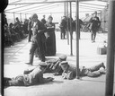
| Description: | Immigrants being detained at Ellis Island. Three boys lay on the ground together. |
| Date: | 08 1917 |
|---|---|
| Description: | World War I recruits scramble over an obstacle during their training, while others watch in the background. |

| Date: | |
|---|---|
| Description: | Medical inspection of immigrants at Ellis Island. |
| Date: | 07 30 1917 |
|---|---|
| Description: | For these World War I recruits seen at an unidentified training camp on Long Island, the enemy was not the Germans, but ferocious "Jersey mosquitos" and th... |

| Date: | 1900 |
|---|---|
| Description: | A group of immigrants, both children and adults, who have just arrived at Ellis Island. |
| Date: | 1969 |
|---|---|
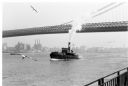
| Description: | The Island's Edge, Williamsburg Bridge, East River. |

| Date: | |
|---|---|
| Description: | Park with stone-lined waterways, surrounded by woods. In the middle of the image is a small island with a rustic stone hut and in the background are stone... |
| Date: | |
|---|---|
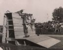
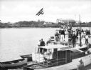
| Description: | Slightly elevated view of a crowd of people standing on boats lined up along a pier to watch a bi-winged airplane flying over the water. Large buildings ar... |
| Date: | |
|---|---|
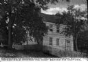
| Description: | The Mother Chick Tavern, where Nathan Hale, widely considered America's first spy during the American Revolutionary War, stopped the night before his captu... |
| Date: | |
|---|---|
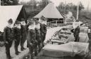
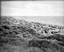
| Description: | Tents line a beach along the Atlantic Ocean. Foliage covers the foreground and several people and vehicles can be seen throughout the camp. |

| Date: | 1780 |
|---|---|
| Description: | Map of New York and parts of the neighboring states. It shows cities, forts, towns, roads, mountains, lakes, and rivers. several different boundary lines a... |

| Date: | 1760 |
|---|---|
| Description: | Map showing upstate New York, Lake Ontario, and the St. Lawrence River during the last, decisive battle of the French and Indian War. The main map shows a ... |

| Date: | 1795 |
|---|---|
| Description: | Detailed map of New York, showing counties, cities, mines, mills, roads, swamps, mountains, lakes and rivers. The map also shows Native American towns and ... |

| Date: | 10 1776 |
|---|---|
| Description: | Broadside map showing the British invasion of New York city in August and September of 1776. The map shows important cities, forts, roads, hills, mountains... |

| Date: | 02 1777 |
|---|---|
| Description: | Map depicting the campaigns of October and November 1776, in Manhattan, Westchester, and part of New Jersey, published only a few months after the conclusi... |

| Date: | 03 1777 |
|---|---|
| Description: | Map showing the British and Hessian attack on Fort Washington in November of 1776. The movements and fortifications of the British and Hessian troops appea... |

| Date: | 11 1781 |
|---|---|
| Description: | Map of New York, Staten Island, and Long Island, showing the placements of forts, and the movement of troops in 1776. The map also includes towns, cities, ... |
If you didn't find the material you searched for, our Library Reference Staff can help.
Call our reference desk at 608-264-6535 or email us at: