 Filter: Categories of Wisconsin Historical Images
Filter: State of New York
Filter: Subject of fortification
Filter: Categories of Wisconsin Historical Images
Filter: State of New York
Filter: Subject of fortification

| Date: | 1968 |
|---|---|
| Description: | A woman sits on the grass reading next to a baby carriage in Fort Tyron Park. A brush-covered hill surmounted by a square tower rises in the background. |
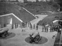
| Date: | |
|---|---|
| Description: | Elevated view of a group of men standing by large guns. |
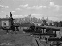
| Date: | |
|---|---|
| Description: | A view of artillery and guns at Fort Jay, built in 1794 to defend Upper New York Bay. The New York cityscape is across the bay. |
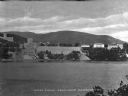
| Date: | |
|---|---|
| Description: | A view of West Point from Garrison, New York, across the river. The military academy was designed in l778, and was built on the bank of the Hudson River. C... |
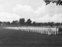
| Date: | |
|---|---|
| Description: | A view of soldiers of the U.S. Military Academy in formation wearing summer uniforms during a parade. |

| Date: | 1760 |
|---|---|
| Description: | Map showing upstate New York, Lake Ontario, and the St. Lawrence River during the last, decisive battle of the French and Indian War. The main map shows a ... |

| Date: | 1778 |
|---|---|
| Description: | Map of the land between Fort Ticonderoga and Albany. It shows cities, forts, mills, roads, mountains, swamps, waterfalls, lakes, and rivers. A few annotati... |

| Date: | 10 1776 |
|---|---|
| Description: | Broadside map showing the British invasion of New York city in August and September of 1776. The map shows important cities, forts, roads, hills, mountains... |

| Date: | 02 1777 |
|---|---|
| Description: | Map depicting the campaigns of October and November 1776, in Manhattan, Westchester, and part of New Jersey, published only a few months after the conclusi... |

| Date: | 03 1777 |
|---|---|
| Description: | Map showing the British and Hessian attack on Fort Washington in November of 1776. The movements and fortifications of the British and Hessian troops appea... |

| Date: | 11 1781 |
|---|---|
| Description: | Map of New York, Staten Island, and Long Island, showing the placements of forts, and the movement of troops in 1776. The map also includes towns, cities, ... |

| Date: | 1776 |
|---|---|
| Description: | Fairly detailed map of New York City and parts of Long Island. It shows streets, roads, wharves, ferries, ship yards, Fort George and the battery, public b... |
If you didn't find the material you searched for, our Library Reference Staff can help.
Call our reference desk at 608-264-6535 or email us at: