 Filter: Categories of Wisconsin Historical Images
Filter: Year of 1700-1799
Filter: Categories of Wisconsin Historical Images
Filter: Year of 1700-1799

| Date: | 07 04 1776 |
|---|---|
| Description: | Hand-drawn map of the area where the Battle of Black's Fort took place. |
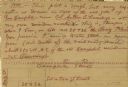
| Date: | 07 04 1776 |
|---|---|
| Description: | Notes written in red ink on the back of the map of the Battle of Black's Fort. |

| Date: | 1755 |
|---|---|
| Description: | From "A map of the British and French dominions in North American with the roads, distances, limits, and extent of the settlements". |

| Date: | 10 12 1774 |
|---|---|
| Description: | The back page of a repaired letter from Maj. Arthur Campbell to William Preston. From Preston and Virginia Papers [Calendar series Volume 1]: "Royal... |
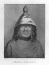
| Date: | 1784 |
|---|---|
| Description: | Plate 39. Portrait from Cook's Third Expedition, 1776-1779, while in Alaska. |

| Date: | 1784 |
|---|---|
| Description: | Plate 41. Scene from Cook's Third Expedition, 1776-1779, while in Alaska. |

| Date: | 1784 |
|---|---|
| Description: | Plate 42. Scene from Cook's Third Expedition, 1776-1779, while in Alaska. |

| Date: | 1784 |
|---|---|
| Description: | Plate 45. Scene from Cook's Third Expedition, 1776-1779, while in Alaska. |

| Date: | 1784 |
|---|---|
| Description: | Plate 50. Portrait from Cook's Third Expedition, 1776-1779, while in Alaska. |
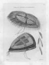
| Date: | 1784 |
|---|---|
| Description: | Plate 56. Drawing from Cook's Third Expedition, 1776-1779, while in Alaska. |

| Date: | 1784 |
|---|---|
| Description: | Plate 57. Scene from Cook's Third Expedition, 1776-1779, while in Alaska. |
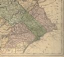
| Date: | 1775 |
|---|---|
| Description: | Detail of Pennsylvania map showing Chester, Philadelphia, and Bucks counties. |

| Date: | 1776 |
|---|---|
| Description: | Map of the Delaware Bay, River, their shoreline, made to aid ships in navigating to Philadelphia. It is oriented with north to the right and shows inlets, ... |

| Date: | 1760 |
|---|---|
| Description: | Map showing the towns, mountains, valleys, corn fields, and rivers of a portion of the Cherokee Nation. A few annotations on the map explain the land and r... |

| Date: | 1781 |
|---|---|
| Description: | Map of the British territory of West Florida, extending from the Mississippi River to the Apalachicola River. It shows the borders, cities, towns, forts, h... |

| Date: | 1795 |
|---|---|
| Description: | Map of Georgia, with its borders extending to the Mississippi River. It shows borders, various boundary lines, counties, cities, towns, Native American lan... |

| Date: | 1761 |
|---|---|
| Description: | Map covering southern Louisiana from Lake Ponchetrain to the Golf of Mexico and from Woods Bay in the west to the islands just east of Bay St. Louis. It sh... |

| Date: | 1793 |
|---|---|
| Description: | Detailed topographical map of the Ohio River between Clarkville and Louisville. It shows plots of farmland, forest, islands, garden plots, houses, Fort Fe... |

| Date: | 1755 |
|---|---|
| Description: | Map of the Great Lakes region during the French and Indian War. It shows in great detail the territories, borders and boundary lines, Native American tribe... |
If you didn't find the material you searched for, our Library Reference Staff can help.
Call our reference desk at 608-264-6535 or email us at:
