 Filter: Categories of Wisconsin Historical Images
Filter: Subject of transportation
Filter: Year of 1600-1699
Filter: Categories of Wisconsin Historical Images
Filter: Subject of transportation
Filter: Year of 1600-1699

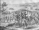
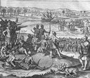
| Date: | 1609 |
|---|---|
| Description: | Illustration of an elevated view of a battle between Iroquois tribe and French on the banks of river. The Iroquois are unclothed and armed with bows and ar... |

| Date: | 1612 |
|---|---|
| Description: | Map of New France, the area that is now eastern Canada and north eastern United States, showing lakes, rivers, and landforms. The locations of several Nati... |

| Date: | 1684 |
|---|---|
| Description: | Map of North America showing some colonies, cities, rivers, lakes, and Native American land. Ship routes spread across both oceans, including one decorated... |

| Date: | 1679 |
|---|---|
| Description: | Decorative and detailed map of the eastern half of North America. Regions, cities, colonies, Native America land, rivers, lakes and some nautical features ... |

| Date: | 1630 |
|---|---|
| Description: | One of the few maps by Dutch cartographer Willem Blaeu depicting the Americas, this map shows regions, settlements, islands, mountains, forests, rivers, an... |

| Date: | 1627 |
|---|---|
| Description: | Map of North and South America showing settlements, rivers, lakes, mountains, islands and regions of the western hemisphere. It includes an inset map of Gr... |

| Date: | 1698 |
|---|---|
| Description: | A sea chart of Hudson's Bay, Greenland, and the Canadian Arctic. This map shows rhumb lines extending from various points including two compass roses. Coas... |

| Date: | 1697 |
|---|---|
| Description: | Father Hennepin's map in French of the upper lakes. |
| Date: | 1655 |
|---|---|
| Description: | Scene from Jamestown Settlement in which the brothers of Pocahontas visit her. |

| Date: | 1673 |
|---|---|
| Description: | P. Marquette en Joliet, gedan in't jaar 1673. |
| Date: | 1655 |
|---|---|
| Description: | Scene from Jamestown Settlement in Virginia, 1610. |
| Date: | 1655 |
|---|---|
| Description: | Scene from the Laudonnière Expedition in South Carolina, ca. 1564. |
| Date: | 1655 |
|---|---|
| Description: | Scene from Christopher Columbus' fourth voyage, 1502-1504. |

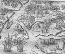
| Date: | 1688 |
|---|---|
| Description: | This map includes vignettes of Amerindian life with text describing geography, culture, and exploration activity, written in French. The Great Lakes, river... |
| Date: | 1655 |
|---|---|
| Description: | Scene from near Jamestown Settlement in Virginia, ca. 1614. The Chickahominy tribe's proximity to Jamestown meant they had early contact with the English.... |
| Date: | 1655 |
|---|---|
| Description: | Scene from near Jamestown Settlement in Virginia, 1615. |
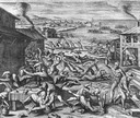
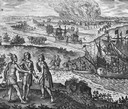
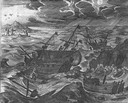
| Date: | 1655 |
|---|---|
| Description: | Scene from Jamestown Settlement, 1622, purporting to show the massacre of 347 settlers by Openchancanough and his alliance of tribes in the Jamestown area. |

| Date: | 1655 |
|---|---|
| Description: | Engraving made after a watercolor painting by John White during the Barlowe Expedition in Virginia, 1585-1587. |
| Date: | 1655 |
|---|---|
| Description: | Scene of the Jamestown Settlement in Virginia, ca. 1614 showing men at the water's edge being beckoned by mermaids. |

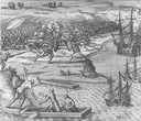
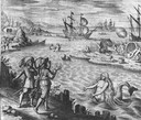
| Date: | 1655 |
|---|---|
| Description: | Christopher Columbus begins his first expedition, 1492. |
If you didn't find the material you searched for, our Library Reference Staff can help.
Call our reference desk at 608-264-6535 or email us at: