 Filter: Categories of Wisconsin Historical Images
Filter: Subject of indians of north america
Filter: Subject of brotherton indians
Filter: Categories of Wisconsin Historical Images
Filter: Subject of indians of north america
Filter: Subject of brotherton indians
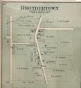
| Date: | 1893 |
|---|---|
| Description: | Plat map of Brothertown in Calumet County. |

| Date: | 1857 |
|---|---|
| Description: | A map of the state of Wisconsin and the southeastern portion of the Territory of Minnesota, showing the Wisconsin reservations of the Oneida, Menominee, St... |

| Date: | 1858 |
|---|---|
| Description: | A survey map that shows the status of township surveys in Wisconsin. At that point, the majority of the state had been surveyed and platted, with the area... |
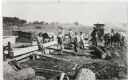
| Date: | 1925 |
|---|---|
| Description: | Chief Niles and other Brotherton men sawing logs. |
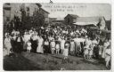
| Date: | 07 01 1917 |
|---|---|
| Description: | View of a large group of people gathered for a Homecoming celebration. A young woman in the foreground is identified as Daisy Helen Hicken. |

| Date: | 1836 |
|---|---|
| Description: | This negative photostat map shows the "oak tree, place of beginning" on the division line between Stockbridge and Brothertown Indians, and Governor Porter'... |

| Date: | 1974 |
|---|---|
| Description: | This map draws content from a map originally created by George Featherstongaugh in 1840. The map shows streets, land ownership, the Brotherton Indian reser... |
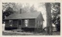
| Date: | 09 14 1936 |
|---|---|
| Description: | View toward a wooden house, surrounded by trees. Caption reads: "This ancient dwelling of Louise Fowler, a pioneer Brothertown Indian, is the only dwelling... |
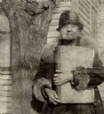
| Date: | 03 1934 |
|---|---|
| Description: | View of a woman holding a large bound volume and standing next to a tree. Caption reads: "An Indian woman of over 70 [Lura Fowler Kindness] who lives by he... |
If you didn't find the material you searched for, our Library Reference Staff can help.
Call our reference desk at 608-264-6535 or email us at: