 Filter: Categories of Wisconsin Historical Images
Filter: Subject of geology
Filter: Categories of Wisconsin Historical Images
Filter: Subject of geology

| Date: | |
|---|---|
| Description: | An exhibit of petrified wood sections and other objects on tables and display cases in the Zerk Museum. Paintings, photographs, jewelry and other objects a... |
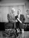
| Date: | 08 09 1957 |
|---|---|
| Description: | Richard C. Emmons (left), Professor of Geology at U.W., being presented thirteen Geiger counters and scintillation counters by E.L. Diener, manager of the ... |

| Date: | 01 18 2015 |
|---|---|
| Description: | Inside view of display cases of rocks and geodes along the front windows of the store. "Burnie's Rock Shop" is painted in reverse on the window. Two street... |

| Date: | 1840 |
|---|---|
| Description: | This map is pencil on paper and shows rivers, granite locations, and selected landmarks. Relief is shown by hachures. |

| Date: | 1910 |
|---|---|
| Description: | This map shows the Soo Line railroad and Arpin Hardwood Lumber Company lands in red. The top margin of the map reads: "Wisconsin, the safest state in the U... |

| Date: | 1828 |
|---|---|
| Description: | Increase Lapham's drawing and description of an earth borer for his handwritten manuscript, Notes and Accounts of Canals, Particularly the Ohio Canal Ne... |
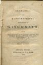
| Date: | 1844 |
|---|---|
| Description: | Title page of Increase Lapham's A Geographical and Topographical Description of Wisconsin published by P.C. Hale of Milwaukee, Wisconsin. |

| Date: | 12 22 1830 |
|---|---|
| Description: | Increase Lapham's drawing of the geological profile between the Sandusky plains and Portsmouth, Ohio. |

| Date: | 1828 |
|---|---|
| Description: | Drawing by Increase Lapham showing the geological profile of the land between Utica and Knob Creek, Kentucky at a scale of 1/2 inch to a mile. |
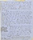
| Date: | 06 28 1850 |
|---|---|
| Description: | Letter from Increase Lapham to his wife, Ann Maria Alcott, in Milwaukee. Lapham was at Aztalan and wrote to Anna regarding the geology of the region. He in... |
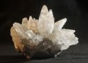
| Date: | 11 12 2013 |
|---|---|
| Description: | A dogtooth calcite specimen from the mineral collection of Ferdinand Hotz at the University of Wisconsin Geology Museum. The specimen is approximately thre... |
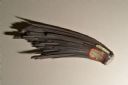
| Date: | 11 12 2013 |
|---|---|
| Description: | A specimen of emerald in matrix from the mineral collection of Ferdinand Hotz at the University of Wisconsin Geology Museum. |
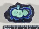
| Date: | 11 12 2013 |
|---|---|
| Description: | A cut and polished azurite malachite nodule from the mineral collection of Ferdinand Hotz at the University of Wisconsin Geology Museum. Azurite and malach... |
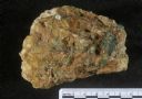
| Date: | 11 12 2013 |
|---|---|
| Description: | A hematite fan, approximately six inches in length, from the mineral collection of Ferdinand Hotz at the University of Wisconsin Geology Museum. This speci... |

| Date: | 1917 |
|---|---|
| Description: | A geological survey map that map of southeastern Wisconsin shows the surface deposits east of the Wisconsin River, from the Illinois state line north to Ne... |
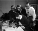
| Date: | 03 26 1957 |
|---|---|
| Description: | George Hanson (seated foreground center), state geologist, peers into a microscope while examining a diamond. Leaning in to look on are (left to right) Pro... |
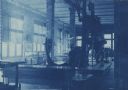
| Date: | 1910 |
|---|---|
| Description: | Cyanotype print of the interior of the Geology Museum in Science Hall on the University of Wisconsin-Madison campus. View towards corner of a room with win... |

| Date: | 1912 |
|---|---|
| Description: | This map is pen, ink, and pencil on tracing paper. The map was traced from U.S. Geological Survey map of Wisconsin, compiled in 1910-1911, and printed in 1... |

| Date: | 1870 |
|---|---|
| Description: | A geological survey map of Wisconsin, with hand-colored portions showing the surveys completed from 1873 to 1875. Although the title and legend are in Wel... |

| Date: | 1872 |
|---|---|
| Description: | A series of four hand-colored, geological maps of Wisconsin. Starting from the top of the page, the first map is of a section along the line of the 4th pri... |
If you didn't find the material you searched for, our Library Reference Staff can help.
Call our reference desk at 608-264-6535 or email us at: