Filter: Categories of Wisconsin Historical Images
Filter: Subject of Wisconsin River (Wis.)
Filter: Subject of trees
Filter: Categories of Wisconsin Historical Images
Filter: Subject of Wisconsin River (Wis.)
Filter: Subject of trees
| Date: | |
|---|---|
| Description: | Downstream from channel behind Steamboat Rock. Two children are standing near a rowboat in the water at the shoreline. |

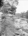
| Date: | |
|---|---|
| Description: | Two men are on a raft. One man is bending to lift a piece of wood, and the second man is throwing a rope to a third man on the shore. |
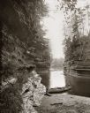
| Date: | |
|---|---|
| Description: | H.H. Bennett with camera near Steamboat Rock. There is a man on shore reading, and a woman in a canoe at the edge of the river. |

| Date: | |
|---|---|
| Description: | View down sandy beach towards Miriam and Ruth Bennett wading in river near Romance Cliff at a sand bar above High Rock. |
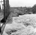
| Date: | 1916 |
|---|---|
| Description: | Water churns under a railroad bridge as the spring thaw swells the Wisconsin River. |

| Date: | 04 18 1965 |
|---|---|
| Description: | Wisconsin River in flood, looking downstream. |
| Date: | 08 13 1961 |
|---|---|
| Description: | A Wisconsin River swamp. The swampy area is framed by trees with more trees in the background hidden by fog. |
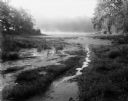
| Date: | 09 22 1962 |
|---|---|
| Description: | Elevated view of trees and pool of water near the Wisconsin River in Pauquette Park. |

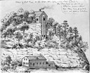
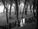
| Date: | 1869 |
|---|---|
| Description: | Birds-eye drawing of Boscobel, Grant County, depicts street names and street layouts, houses, rivers and trees. A reference key at the bottom of the map sh... |

| Date: | 1870 |
|---|---|
| Description: | Bird's-eye map of Prairie du Sac. |

| Date: | 1870 |
|---|---|
| Description: | Sauk City is the oldest incorporated village in Wisconsin (incorporated in 1854) and also has the oldest organized volunteer fire department in the state, ... |

| Date: | 1883 |
|---|---|
| Description: | Bird's-eye map of Prairie du Sac, Wisconsin with an inset of Clifton. |

| Date: | 1879 |
|---|---|
| Description: | This map is a bird's-eye view of Wausau, the County Seat of Marathon County. The map features an index of points of interest. |
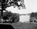
| Date: | |
|---|---|
| Description: | View from the Sherman House overlooking expansive lawn and river. |
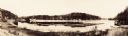
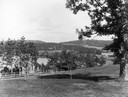
| Date: | |
|---|---|
| Description: | Panoramic view of the Upper Dells River as seen from the Dell House. |

| Date: | 1928 |
|---|---|
| Description: | "The Dells," a brochure issued by the Chicago, Milwaukee & St. Paul and Pacific Railroad to advertise the Wisconsin Dells, a destination only five hours fr... |
If you didn't find the material you searched for, our Library Reference Staff can help.
Call our reference desk at 608-264-6535 or email us at: