 Filter: Categories of Wisconsin Historical Images
Filter: Subject of Wisconsin
Filter: Categories of Wisconsin Historical Images
Filter: Subject of Wisconsin

| Date: | 1974 |
|---|---|
| Description: | Map of Wisconsin with drawings illustrating historic places and events throughout the state. The Great Seal of the State of Wisconsin appears at the top ri... |
| Date: | 1956 |
|---|---|
| Description: | Six Native American boys and teenagers take part in an archery competition. They are holding their bows and carrying arrows in a bag on their backs. Riley ... |

| Date: | |
|---|---|
| Description: | Native American women and children wait in line by a bus to be tested for tuberculosis by the Wisconsin Anti-Tuberculosis Association. A sign points the wa... |
| Date: | |
|---|---|
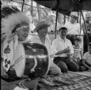
| Description: | Several Indian men kneel on a rug to play the moccasin game. One man is holding a drum and wearing a headdress (also called a war bonnet). |
| Date: | |
|---|---|
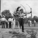
| Description: | Sam Carley Blowsnake and Jacob Lone Tree stand side by side, drawing back arrows in their bows. People are standing in the background. |

| Date: | |
|---|---|
| Description: | A night view of automobiles in the parking lot at the Stand Rock Amphitheater, where the Stand Rock Indian Ceremonial is performed. |

| Date: | |
|---|---|
| Description: | Cigar box cover with a head and shoulders portrait of Nelson Dewey. Beneath his portrait is a Native American headdress, a tomahawk, a stone club and a qui... |
| Date: | 06 19 1919 |
|---|---|
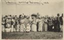
| Description: | A gathering of Native American women, some holding flags, to welcome home soldiers returning from WWI on Corpus Christi Day. There are men in the backgroun... |

| Date: | 1937 |
|---|---|
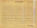
| Description: | Pictorial map showing historical events and locations within the state of Wisconsin, as well as waterways and counties. Original caption on the bottom marg... |

| Date: | 1900 |
|---|---|
| Description: | This map shows landownership circa 1848 in the old Stockbridge Indian reservation on Lake Winnebago in Calumet County. It is oriented with north to the lef... |
| Date: | 1955 |
|---|---|
| Description: | This map shows landownership in the old Stockbridge Indian reservation on Lake Winnebago in Calumet County. The lots are numbered and labeled by owner. A b... |

| Date: | 1947 |
|---|---|
| Description: | This map shows the territories of Chippewa, Sioux, Winnebago, and Monomone tribes. It also shows navigation notes for rivers and lakes, Indian villages, hi... |

| Date: | 1900 |
|---|---|
| Description: | This map shows a line, marked with latitude and longitude coordinates that runs through Prairie du Chien. Only a few features beyond this line are displaye... |
| Date: | |
|---|---|
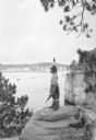
| Description: | A Native American Indian in native dress, including a beaded bandolier and feathered headdress, gazing out to the Wisconsin River. He is standing on a rock... |

| Date: | |
|---|---|
| Description: | A young Native American Indian boy in traditional dress is posing on a rock formation above the Wisconsin River. In the background is a steamboat on the ri... |

| Date: | |
|---|---|
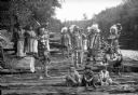
| Description: | Group portrait of older men, with younger men and a boy, posing on a rock formation above the Wisconsin River. They are all wearing traditional clothing, i... |
| Date: | |
|---|---|
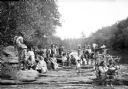
| Description: | A large group of Native Americans, men, women and children, posing on rocks along the Wisconsin River. They are wearing traditional clothing, and some of t... |
| Date: | |
|---|---|
| Description: | Group portrait of Native Americans, including Ho-Chunk, Sioux, Kiowa and southwestern Native American tribes, posing on rocks along the Wisconsin River wea... |
| Date: | |
|---|---|
| Description: | Outdoor portrait of a Native American man with his arms crossed over his chest standing on rocks near the Wisconsin River. He is wearing a headdress, a pat... |

| Date: | 1925 |
|---|---|
| Description: | This map shows trails, mounds, villages, corn fields, and contemporary civil townships; some villages and features include both Indian and English place na... |
If you didn't find the material you searched for, our Library Reference Staff can help.
Call our reference desk at 608-264-6535 or email us at: