 Filter: Categories of Wisconsin Historical Images
Filter: Subject of Wisconsin
Filter: Year of 1800-1899
Filter: Subject of water
Filter: Categories of Wisconsin Historical Images
Filter: Subject of Wisconsin
Filter: Year of 1800-1899
Filter: Subject of water

| Date: | 1893 |
|---|---|
| Description: | Back of painting reads: "Madison in June 1837 after photo taken by E.E. Bailey" and "Peck's cabin by Dengel." The Eben Peck cabin was the first house built... |

| Date: | 1852 |
|---|---|
| Description: | Illustration of four Indians on Madeline Island with a canoe in the water on the shore. |

| Date: | 1842 |
|---|---|
| Description: | This hand-colored lithograph of the second Fort Howard, with Indians canoeing on the Fox River, shows the hospital built 1834-1835 outside the stockade on ... |

| Date: | 06 1837 |
|---|---|
| Description: | Lithograph based on a painting by Mrs. E.E. Bailey showing the Peck cabin, the first house in Madison. In addition to the cabin, the lithograph includes a ... |
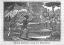
| Date: | 1845 |
|---|---|
| Description: | Engraving depicting the defeat of Black Hawk by General Henry Atkinson at the Battle of Bad Axe on August 2, 1832. The engraving depicts Federal Regulars a... |
| Date: | 1877 |
|---|---|
| Description: | Photograph of a painting of the exterior of the Eben Peck cabin by Mrs. E.E. Bailey. The location of this original painting is unknown. |

| Date: | 1846 |
|---|---|
| Description: | A hand-colored map of Wisconsin shows the counties in the state south and east of the Wisconsin and Fox rivers and the locations of Indian lands to the nor... |

| Date: | 1899 |
|---|---|
| Description: | This color map, originally published in the Smithsonian Institution Bureau of American Ethnology's 18th annual report, shows the Indian land cessions in Wi... |

| Date: | 1858 |
|---|---|
| Description: | A survey map that shows the status of township surveys in Wisconsin. At that point, the majority of the state had been surveyed and platted, with the area... |

| Date: | 1851 |
|---|---|
| Description: | Map of a portion of Merton including the Bark River, a mill, Fort Hill, and Indian mounds. |

| Date: | 1880 |
|---|---|
| Description: | A hand-colored map of the Chippewa, Price, Taylor and the northern part of Clark counties, which shows the locations of farmhouses, schoolhouses, churches,... |

| Date: | 1851 |
|---|---|
| Description: | A survey map of Wisconsin and eastern Minnesota, with the township surveys for portions of the Saint Croix region in progress. The maps also show the Meno... |

| Date: | 1864 |
|---|---|
| Description: | This map of the entire state of Wisconsin depicts the township survey grid and identifies counties, named towns, cities and villages, rivers, lakes, railro... |

| Date: | 1865 |
|---|---|
| Description: | This map of the entire state of Wisconsin depicts the township survey grid and identifies counties, named towns, cities and villages, rivers, lakes, railro... |

| Date: | 1867 |
|---|---|
| Description: | A hand-colored map of Wisconsin showing the state’s township grid, lakes, rivers, railroads, as well as the locations of towns, counties and the reservatio... |

| Date: | 1871 |
|---|---|
| Description: | This map of Wisconsin and surrounding states depicts the township survey grid and identifies counties, named towns, cities and villages, rivers, lakes, rai... |

| Date: | 1871 |
|---|---|
| Description: | This map of Wisconsin and surrounding states depicts the township survey grid and identifies counties, named towns, cities and villages, rivers, lakes, rai... |

| Date: | 1875 |
|---|---|
| Description: | This hand-colored map of Wisconsin and the western portion of Michigan's Upper Peninsula depicts the township survey grid and identifies counties, named to... |

| Date: | 1878 |
|---|---|
| Description: | A hand-colored, cloth mounted, sectional map of Wisconsin and the western portion of Michigan’s Upper Peninsula, showing the township grid, railroads, town... |

| Date: | 1880 |
|---|---|
| Description: | A hand-colored, sectional map of Wisconsin showing the township grid, railroads, counties, towns, cities, villages, and the Menomonee, Oneida, Flambeau, an... |
If you didn't find the material you searched for, our Library Reference Staff can help.
Call our reference desk at 608-264-6535 or email us at: