 Filter: Categories of Wisconsin Historical Images
Filter: Subject of Wisconsin
Filter: Subject of lakes
Filter: Categories of Wisconsin Historical Images
Filter: Subject of Wisconsin
Filter: Subject of lakes

| Date: | 1923 |
|---|---|
| Description: | This map shows counties, roads, Lake Superior, Lake Michigan, and portions of surrounding states. Included is an index to cities, villages and other places... |

| Date: | 1921 |
|---|---|
| Description: | This map shows counties, roads, Lake Superior, Lake Michigan, and portions of surrounding states. Included is an index to cities, villages and other places... |

| Date: | 1845 |
|---|---|
| Description: | This map shows lakes, rivers, Chippewa land, the U.S. Mineral Land Agency, boundary between U.S. and Canada, Methodist and Catholic missions, and American ... |

| Date: | 1949 |
|---|---|
| Description: | This pictorial map shows the United States west of the Mississippi, including Indian Tribes, historic trails, forts, trading posts, mountain ranges, lakes ... |

| Date: | 1974 |
|---|---|
| Description: | Map of Wisconsin with drawings illustrating historic places and events throughout the state. The Great Seal of the State of Wisconsin appears at the top ri... |

| Date: | 1937 |
|---|---|
| Description: | Pictorial map showing historical events and locations within the state of Wisconsin, as well as waterways and counties. Original caption on the bottom marg... |
| Date: | 1955 |
|---|---|
| Description: | This map shows landownership in the old Stockbridge Indian reservation on Lake Winnebago in Calumet County. The lots are numbered and labeled by owner. A b... |

| Date: | 1947 |
|---|---|
| Description: | This map shows the territories of Chippewa, Sioux, Winnebago, and Monomone tribes. It also shows navigation notes for rivers and lakes, Indian villages, hi... |

| Date: | 1900 |
|---|---|
| Description: | This map shows a line, marked with latitude and longitude coordinates that runs through Prairie du Chien. Only a few features beyond this line are displaye... |

| Date: | 1982 |
|---|---|
| Description: | This map shows the location of major settlement regions for various ethnic groups. Includes a legend in lower left hand corner. Sparse settlement is repres... |

| Date: | 1899 |
|---|---|
| Description: | This map shows color coded and numbered regions of Indian land cessions. Lake Superior and Lake Michigan are labeled and other lakes and rivers are shown. ... |

| Date: | 1899 |
|---|---|
| Description: | This map shows color coded and numbered regions of Indian land cessions. Lake Superior and Lake Michigan are labeled and other lakes and rivers are shown. ... |

| Date: | 1900 |
|---|---|
| Description: | This manuscript map shows outline of Fort Winnebago reserve land, Fort Winnebago, claim of A. Grignon, and Indian boundaries. The Fox River and Swan Lake a... |

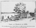
| Date: | 1877 |
|---|---|
| Description: | Engraving of the Peck Cabin, after the painting by Mrs. E.E. Bailey. Caption at bottom reads: "First House in Madison. 1837." |

| Date: | 1758 |
|---|---|
| Description: | This detailed map of north eastern America shows the boundaries, cities, mountains, rivers, lakes, Native American land and towns, and roads from east of t... |

| Date: | 1720 |
|---|---|
| Description: | Map showing the course of the Mississippi River from the Gulf of Mexico up past Lake Superior into Canada. It shows the towns, Native American tribes and l... |

| Date: | 1755 |
|---|---|
| Description: | Map of the Great Lakes region during the French and Indian War. It shows in great detail the territories, borders and boundary lines, Native American tribe... |
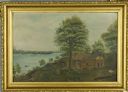
| Date: | |
|---|---|
| Description: | Painting of the Eben Peck cabin, the first house in Madison, was built in June, 1837. Text on back of art board: "Madison in June 1837." Painting likely ba... |
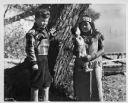
| Date: | 1936 |
|---|---|
| Description: | Walker Reid (1929-2016) standing alongside tree with Indian girl. Reid Walker shown is 7-years-old, and is the son of Carol McMillan Reid. Portrait taken a... |
| Date: | |
|---|---|
| Description: | Photograph of a woodcut of the Eben and Roseline Peck cabin. It was built by or for Roseline, the first white settler in Madison. The drawing was inspired ... |
If you didn't find the material you searched for, our Library Reference Staff can help.
Call our reference desk at 608-264-6535 or email us at: