 Filter: Categories of Wisconsin Historical Images
Filter: Subject of Wisconsin
Filter: Subject of arts
Filter: Subject of land
Filter: Categories of Wisconsin Historical Images
Filter: Subject of Wisconsin
Filter: Subject of arts
Filter: Subject of land

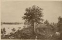
| Date: | 1893 |
|---|---|
| Description: | Back of painting reads: "Madison in June 1837 after photo taken by E.E. Bailey" and "Peck's cabin by Dengel." The Eben Peck cabin was the first house built... |

| Date: | 1955 |
|---|---|
| Description: | Artist's conception of ancient village of Aztalan, fortified with high walls surrounding it. |
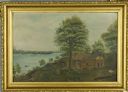
| Date: | 1877 |
|---|---|
| Description: | Photograph of a painting of the exterior of the Eben Peck cabin by Mrs. E.E. Bailey. The location of this original painting is unknown. |

| Date: | 1688 |
|---|---|
| Description: | This map includes vignettes of Amerindian life with text describing geography, culture, and exploration activity, written in French. The Great Lakes, river... |

| Date: | |
|---|---|
| Description: | Letterhead of the Kewaskum Mutual Fire Insurance Company of Washington County, Wisconsin, with a Native American man wearing buckskin clothes and leggings ... |

| Date: | 1851 |
|---|---|
| Description: | Map of a portion of Merton including the Bark River, a mill, Fort Hill, and Indian mounds. |

| Date: | 1979 |
|---|---|
| Description: | A map of Southern Wisconsin and northern Illinois showing the areas inhabited by the Ho-Chuck, formerly known as the Winnebago. Some of the location names ... |

| Date: | |
|---|---|
| Description: | Cigar box cover with a head and shoulders portrait of Nelson Dewey. Beneath his portrait is a Native American headdress, a tomahawk, a stone club and a qui... |

| Date: | 1877 |
|---|---|
| Description: | Engraving of the Peck Cabin, after the painting by Mrs. E.E. Bailey. Caption at bottom reads: "First House in Madison. 1837." |

| Date: | 1758 |
|---|---|
| Description: | This detailed map of north eastern America shows the boundaries, cities, mountains, rivers, lakes, Native American land and towns, and roads from east of t... |

| Date: | 1720 |
|---|---|
| Description: | Map showing the course of the Mississippi River from the Gulf of Mexico up past Lake Superior into Canada. It shows the towns, Native American tribes and l... |

| Date: | 1755 |
|---|---|
| Description: | Map of the Great Lakes region during the French and Indian War. It shows in great detail the territories, borders and boundary lines, Native American tribe... |

| Date: | 1959 |
|---|---|
| Description: | Slightly elevated view of Ho Chunk performing at the Stand Rock Indian Ceremonial at night. A group of men and women are dancing in a pattern, wearing Nati... |
| Date: | |
|---|---|
| Description: | Painting of the Eben Peck cabin, the first house in Madison, was built in June, 1837. Text on back of art board: "Madison in June 1837." Painting likely ba... |

| Date: | 1952 |
|---|---|
| Description: | Women dressed in buckskins, performing the Wild Goose dance as men in headdresses watch. |

| Date: | |
|---|---|
| Description: | Native American Indian drummers, dressed in ceremonial clothing and headdresses, are lined up and walking up a path. |
If you didn't find the material you searched for, our Library Reference Staff can help.
Call our reference desk at 608-264-6535 or email us at: