 Filter: Categories of Wisconsin Historical Images
Filter: Subject of Waterfalls
Filter: Subject of rivers
Filter: Categories of Wisconsin Historical Images
Filter: Subject of Waterfalls
Filter: Subject of rivers

| Date: | 1909 |
|---|---|
| Description: | A black and white photographic postcard view looking up a river toward a waterfall. Caption reads: "The Cascades." |
| Date: | |
|---|---|
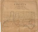
| Description: | Shows lot and block numbers, St. Croix and Lake Superior Railroad, streets, Apple River, waterfalls, and public squares in the paper city of Puebla, Wiscon... |
| Date: | |
|---|---|
| Description: | View looking down at Skillet Creek Falls, which are surrounded by rocks, trees and foliage. Skillet Creek, located on private land, flows to Pewit's Nest, ... |

| Date: | |
|---|---|
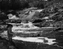
| Description: | View looking up towards rapids in a small river flanked by large rocks, trees and bushes. |

| Date: | |
|---|---|
| Description: | View up center of river with rushing waters, surrounded by rock cliffs. |

| Date: | |
|---|---|
| Description: | View from rocky shoreline looking up at Fylers Falls, a waterfall surrounded by rock cliffs. |

| Date: | |
|---|---|
| Description: | Elevated view looking down at a steep waterfall surrounded by cliffs. The tops of the cliffs and surrounding area are covered by trees and shrubs. A large ... |

| Date: | |
|---|---|
| Description: | View from rocky shoreline across a pool in a river with a small waterfall in the background. Trees and shrubs line the opposite shoreline. |

| Date: | |
|---|---|
| Description: | Elevated view looking across towards Big Manitou Falls, a waterfall in Pattison State Park. The falls are surrounded by trees and rocks. Pattison State Par... |

| Date: | |
|---|---|
| Description: | View looking up to two waterfalls, which flow side by side. |

| Date: | |
|---|---|
| Description: | View across water looking up towards waterfall in a river, surrounded by trees. There are wood posts, perhaps part of a dam, along the top of the waterfall... |

| Date: | 1846 |
|---|---|
| Description: | This map shows the plotting of the various townships in Wisconsin, both those that had been surveyed and some outlines for those which have not. A note in ... |
| Date: | |
|---|---|
| Description: | View along shoreline towards a man fishing on a river with a series of small waterfalls behind him. |

| Date: | 1758 |
|---|---|
| Description: | This map of the north-west hemisphere shows the cities, lakes, rivers, mountains, and political borders. In the upper left corner sits a decorative cartouc... |

| Date: | 1783 |
|---|---|
| Description: | This map is hand-colored and shows the boundaries of British, Spanish, and the newly recognized American claims, as well as the fishing rights granted to F... |

| Date: | 1790 |
|---|---|
| Description: | This map of the north eastern states shows roads, rivers, lakes, waterfalls, mountains, cities, forts, mills, the Oneida Reservation, and "New York Donatio... |

| Date: | 1766 |
|---|---|
| Description: | This map of North America shows the boundaries of European claims at the end of the French and Indian war. The British colonies extend to the Mississippi. ... |

| Date: | 1780 |
|---|---|
| Description: | Map of North America east of Mexico showing colonial boundaries, forts, cities, Native American land, mountains, waterfalls, lakes, and rivers. Short notes... |

| Date: | 1796 |
|---|---|
| Description: | Map of the United Sates, showing the borders between the states and territories, a few cities, mountains, portages, waterfalls, lakes, and rivers. Tennesse... |

| Date: | 1775 |
|---|---|
| Description: | Map of Boston and surrounding regions, from Massachusetts Bay to the Connecticut River, and including part of southern New Hampshire. It shows the colonies... |
If you didn't find the material you searched for, our Library Reference Staff can help.
Call our reference desk at 608-264-6535 or email us at: