 Filter: Categories of Wisconsin Historical Images
Filter: Subject of Waterfalls
Filter: Subject of lakes
Filter: Categories of Wisconsin Historical Images
Filter: Subject of Waterfalls
Filter: Subject of lakes
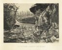
| Date: | 1866 |
|---|---|
| Description: | Cliffs along Lu-la Lake. A waterfall is in the background. Plate 15 |
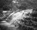
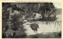
| Date: | 1921 |
|---|---|
| Description: | Water pouring between the logs of the Mirror Lake Dam. The opposite shoreline has trees and plants covering a steep, rocky cliff. |

| Date: | 1941 |
|---|---|
| Description: | A tourist map of Marinette County, Wisconsin that includes indexes of the lakes and rivers in the county which also identify the fish present, a list of ra... |

| Date: | |
|---|---|
| Description: | A map of the western Upper Peninsula of Michigan and Wisconsin north of Lake Winnebago and east of Lake Pepin and the mouth of the Saint Louis River on Lak... |
| Date: | |
|---|---|
| Description: | We've at least been able to conserve something if it's only the idea of conserving for conservation's sake But the community interests ought to come fir... |

| Date: | 09 04 1885 |
|---|---|
| Description: | Exterior and interior bill of fare from The Chequamegon, with views on the back of rock formations, waterfalls, a spot illustration of a train going over a... |
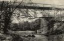
| Date: | 1910 |
|---|---|
| Description: | View from shoreline looking up at the bridge, and the dam. There is a building at the base on the bridge on the opposite shoreline on the right, and anothe... |
| Date: | 1920 |
|---|---|
| Description: | Elevated view from shoreline of Glen Loch in Irvine Park. Caption reads: "Dam at Glen Loch, Irvine Park, Chippewa Falls, Wis." |

| Date: | 1846 |
|---|---|
| Description: | This map shows the plotting of the various townships in Wisconsin, both those that had been surveyed and some outlines for those which have not. A note in ... |

| Date: | 1758 |
|---|---|
| Description: | This map of the north-west hemisphere shows the cities, lakes, rivers, mountains, and political borders. In the upper left corner sits a decorative cartouc... |

| Date: | 1783 |
|---|---|
| Description: | This map is hand-colored and shows the boundaries of British, Spanish, and the newly recognized American claims, as well as the fishing rights granted to F... |

| Date: | 1790 |
|---|---|
| Description: | This map of the north eastern states shows roads, rivers, lakes, waterfalls, mountains, cities, forts, mills, the Oneida Reservation, and "New York Donatio... |

| Date: | 1766 |
|---|---|
| Description: | This map of North America shows the boundaries of European claims at the end of the French and Indian war. The British colonies extend to the Mississippi. ... |

| Date: | 1780 |
|---|---|
| Description: | Map of North America east of Mexico showing colonial boundaries, forts, cities, Native American land, mountains, waterfalls, lakes, and rivers. Short notes... |

| Date: | 1796 |
|---|---|
| Description: | Map of the United Sates, showing the borders between the states and territories, a few cities, mountains, portages, waterfalls, lakes, and rivers. Tennesse... |

| Date: | 1775 |
|---|---|
| Description: | Map of Boston and surrounding regions, from Massachusetts Bay to the Connecticut River, and including part of southern New Hampshire. It shows the colonies... |

| Date: | 1780 |
|---|---|
| Description: | Map of eastern Massachusetts, Rhode Island, eastern Connecticut, and small portions of New Hampshire and Vermont. It shows the boundaries, counties, citie... |

| Date: | 1795 |
|---|---|
| Description: | Map of Vermont showing counties, townships, cities, roads, mountains, lakes, and rivers. A forest and waterfall scene decorates the title cartouche in the ... |

| Date: | 1760 |
|---|---|
| Description: | Map showing upstate New York, Lake Ontario, and the St. Lawrence River during the last, decisive battle of the French and Indian War. The main map shows a ... |

| Date: | 1778 |
|---|---|
| Description: | Map of the land between Fort Ticonderoga and Albany. It shows cities, forts, mills, roads, mountains, swamps, waterfalls, lakes, and rivers. A few annotati... |
If you didn't find the material you searched for, our Library Reference Staff can help.
Call our reference desk at 608-264-6535 or email us at: