 Filter: Categories of Wisconsin Historical Images
Filter: Subject of Water-supply
Filter: Subject of cities and towns
Filter: Subject of transportation
Filter: Categories of Wisconsin Historical Images
Filter: Subject of Water-supply
Filter: Subject of cities and towns
Filter: Subject of transportation
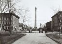
| Date: | 1890 |
|---|---|
| Description: | The Madison water tower and farmers' market as seen through the stone gateway at the East Washington Avenue entrance to the Capitol Park. The building on t... |
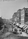
| Date: | |
|---|---|
| Description: | View up West Water Street from Grand Avenue with street cars. |

| Date: | 1896 |
|---|---|
| Description: | A portion of John B. Heim's map of the Water Works System of Madison showing the size of the third Wisconsin Capitol (228' x 226') in comparison with the C... |
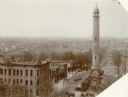
| Date: | 1906 |
|---|---|
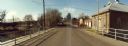
| Description: | Water tower near East Washington Avenue, that stood from 1890 to 1920. Horse-drawn vehicles are parked at the base of the tower. |
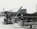
| Date: | 1946 |
|---|---|
| Description: | International I-4 industrial tractor with crane owned by the Milwaukee Waterworks. Original caption reads: "The city of Milwaukee, Wisconsin, purchased thi... |
| Date: | 11 16 1989 |
|---|---|
| Description: | View from the Water Street Bridge over the Waupaca River toward the Waupaca Water Department. |

| Date: | |
|---|---|
| Description: | Exterior of Fairmount Water Works with numerous columned buildings overlooking a river with boats moored to a small dock. Another boat is on the river in m... |
| Date: | 1910 |
|---|---|
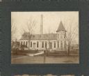
| Description: | The Madison waterworks building, with corner tower and turret. The building was located at the corner of Gorham and Livingston Streets. The large smokesta... |

| Date: | 1887 |
|---|---|
| Description: | City water works system map. Pencil annotation on the top right reads: "Period represented is after 1887 and before Aug. 1891". The middle of the map has a... |

| Date: | 1947 |
|---|---|
| Description: | Lower left hand corner features a legend. "Drawn 1938, revised 1947." Shows water mains, hydrants, corporation limits, city ward divisions, fire proof buil... |

| Date: | 1887 |
|---|---|
| Description: | Shows pipes of various sizes, hydrants with hydrant pressure, valves, wells, and projected lines. |

| Date: | 1892 |
|---|---|
| Description: | Shows pipes of various sizes, hydrants with hydrant pressure, valves, wells, and projected lines. Differs from earlier versions by inclusion of Wingra Park... |

| Date: | 1896 |
|---|---|
| Description: | Shows pipes of various sizes, hydrants with hydrant pressure, valves, wells, projected lines, and suction pipes. Differs from earlier versions by inclusion... |

| Date: | 1894 |
|---|---|
| Description: | This map shows lot and block numbers, railroads, street car tracks, sewers, water mains, gas mains, paved streets, land owned by the Land & River Improveme... |
| Date: | |
|---|---|
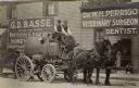
| Description: | Two men sit on top of a water tank wagon which is pulled by two horses. They are posing in front of the W.H. Perrigo Veterinary Surgeon and Dentist office ... |

| Date: | 1892 |
|---|---|
| Description: | This map shows water pipes, hydrants, stop cocks, check valves, fire cysterns, and manholes. Also shown are block numbers, streets, railroads, parks, cemet... |

| Date: | 1892 |
|---|---|
| Description: | This map shows pipes of various sizes, hydrants with hydrant pressure, valves, wells, and projected lines. Includes labels for roadways, blocks, wards, par... |

| Date: | 04 1901 |
|---|---|
| Description: | A Sanborn map of Watertown, including an index and a key. |

| Date: | 11 07 1949 |
|---|---|
| Description: | Subject: "Pipe Lines — TD-6." Where Taken: "NE." Information with photograph reads: "TD-6 owned by J.J. Struzziery-General Contractors, 115 Kittredge St., ... |
If you didn't find the material you searched for, our Library Reference Staff can help.
Call our reference desk at 608-264-6535 or email us at:
