 Filter: Categories of Wisconsin Historical Images
Filter: Subject of Water-supply
Filter: Community of Madison
Filter: Subject of architecture
Filter: Categories of Wisconsin Historical Images
Filter: Subject of Water-supply
Filter: Community of Madison
Filter: Subject of architecture
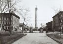
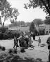
| Date: | 1890 |
|---|---|
| Description: | The Madison water tower and farmers' market as seen through the stone gateway at the East Washington Avenue entrance to the Capitol Park. The building on t... |

| Date: | 1896 |
|---|---|
| Description: | A portion of John B. Heim's map of the Water Works System of Madison showing the size of the third Wisconsin Capitol (228' x 226') in comparison with the C... |
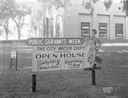
| Date: | 06 10 1949 |
|---|---|
| Description: | Public Servants Week sign "The City Water Dept. invites you to open house" on the lawn in front of main water pumping station, 311 North Hancock at East Go... |
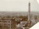
| Date: | 1906 |
|---|---|
| Description: | Water tower near East Washington Avenue, that stood from 1890 to 1920. Horse-drawn vehicles are parked at the base of the tower. |
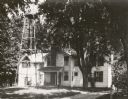
| Date: | 1922 |
|---|---|
| Description: | The J.C. Hawley house, also known as the Evergreens, which stood on a site at Badger Road that later became a highway interchange. A water tower is on the ... |

| Date: | 06 16 1952 |
|---|---|
| Description: | Gail Habermann is shown in front of city hall using a new type of public drinking fountain called an 'angle jet' which replaces the old 'bubbler' type. The... |
| Date: | 08 30 1953 |
|---|---|
| Description: | A crowd lining up at a drinking fountain (bubbler) in Vilas Park. |
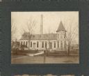
| Date: | 1910 |
|---|---|
| Description: | The Madison waterworks building, with corner tower and turret. The building was located at the corner of Gorham and Livingston Streets. The large smokesta... |

| Date: | 1887 |
|---|---|
| Description: | City water works system map. Pencil annotation on the top right reads: "Period represented is after 1887 and before Aug. 1891". The middle of the map has a... |

| Date: | 1880 |
|---|---|
| Description: | This map is pen-and-ink on paper. The map shows buildings, trees, and water and gas pipes, relief is shown by contours. The back of the map reads: "Univers... |

| Date: | 1887 |
|---|---|
| Description: | Shows pipes of various sizes, hydrants with hydrant pressure, valves, wells, and projected lines. |

| Date: | 1892 |
|---|---|
| Description: | Shows pipes of various sizes, hydrants with hydrant pressure, valves, wells, and projected lines. Differs from earlier versions by inclusion of Wingra Park... |

| Date: | 1896 |
|---|---|
| Description: | Shows pipes of various sizes, hydrants with hydrant pressure, valves, wells, projected lines, and suction pipes. Differs from earlier versions by inclusion... |

| Date: | 1908 |
|---|---|
| Description: | Shows pipes of various sizes, hydrants, valves, and wells. "1907" -- Lower margin. Lake Wingra, Lake Monona, and Lake Mendota are labelled. |

| Date: | 07 05 1961 |
|---|---|
| Description: | A man is bending over to drink from a metal water fixture. Water from the fixture spouted up and back onto the fixture, supposedly making it "sterile." The... |
If you didn't find the material you searched for, our Library Reference Staff can help.
Call our reference desk at 608-264-6535 or email us at: