 Filter: Categories of Wisconsin Historical Images
Filter: Subject of Water
Filter: Subject of armed forces
Filter: Categories of Wisconsin Historical Images
Filter: Subject of Water
Filter: Subject of armed forces
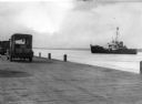
| Date: | 1949 |
|---|---|
| Description: | View from dock of the U.S. Coast Guard ship "Woodrush" arriving at the La Pointe dock to clear ice. Two trucks are on the dock, one with a piano. |
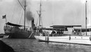
| Date: | 1915 |
|---|---|
| Description: | "Zenya" boat, owned by the Hull family, docked next to a Coast Guard vessel in La Pointe. |
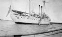
| Date: | 1920 |
|---|---|
| Description: | View from boat of the Coast Guard ship at La Pointe. A shoreline is in the far background. |
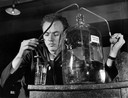
| Date: | 04 04 1943 |
|---|---|
| Description: | This student of the U.S. Coast Guard Hospital Corps School is carefully measuring out a quantity of distilled water for a prescription. Distilled water is ... |
| Date: | 11 13 1942 |
|---|---|
| Description: | Headquarters of the 32nd American Division, on the beach at Pongani, northeast New Guinea. |
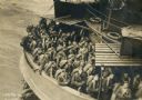
| Date: | |
|---|---|
| Description: | USS "Mt. Vernon" with soldiers aboard departing to fight in World War II. |
| Date: | 1937 |
|---|---|
| Description: | View down the hill toward the U.S. Coast Guard Station on the left with two communications towers on the Lake Michigan shoreline. Railroad tracks are just ... |
| Date: | 1945 |
|---|---|
| Description: | Marines use an International TD-18 Diesel crawler tractor (TracTracTor) to pull an ammunition trailer from the mud. The original caption reads: "JAPANESE A... |
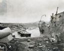
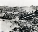
| Date: | 1945 |
|---|---|
| Description: | Parts of destroyed boats and military equipment on the shoreline of Iwo Jima on D-Day. |
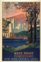
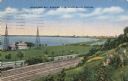
| Date: | 1928 |
|---|---|
| Description: | An original lithograph promoting New York Central Lines railway and the West Point military academy, in a location described as being "In the highlands of ... |
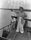
| Date: | 1942 |
|---|---|
| Description: | Olive Brooks, Army Division Engineer Public Relations with her .45 on the "Dolphin", Chucunaque River, Panama. She is pointing her gun out towards the rive... |

| Date: | 1862 |
|---|---|
| Description: | The first in a series of three maps of the Virginia Peninsula. This map details the area from Williamsburg south to Fortress Monroe at Hampton Roads and sh... |

| Date: | 1862 |
|---|---|
| Description: | The second in a series of three maps of the Virginia Peninsula. This map details the area from Williamsburg north to West Point. |

| Date: | 1862 |
|---|---|
| Description: | The third in a series of three maps of the Virginia Peninsula. This map details the area from Harrison's Landing west to Richmond and shows troop positions... |
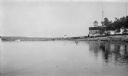
| Date: | 1927 |
|---|---|
| Description: | View from the water of the Plum Island U.S. Coast Guard station. There is a tower in the background. Long piers extend into the lake. |
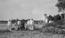
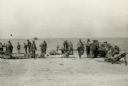
| Date: | 1915 |
|---|---|
| Description: | Six Coastguardsmen pose with an officer on the shore at the Coast Guard Station at Baileys Harbor. The men are identified as (left to right) Reinhart Hicke... |
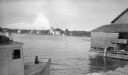
| Date: | 1915 |
|---|---|
| Description: | The Baileys Harbor Coast Guard Life Saving Station viewed from between a fishing boat and a pier warehouse. The station's pier extends into the harbor and ... |
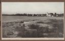
| Date: | 1915 |
|---|---|
| Description: | View from shoreline over water towards the Coast Guard Station and houses at Baileys Harbor. The long pier extending from the station's boathouse is easily... |
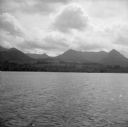
| Date: | 08 11 1943 |
|---|---|
| Description: | A view of Milne Bay, New Guinea (present day Papua New Guinea), from the sea. A ship can be seen on the right, at the shoreline. |
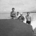
| Date: | 08 11 1943 |
|---|---|
| Description: | Crew of four aboard a Higgins boat, also known as a LCVP, which stands for "Landing Craft, Vehicle, Personnel." Their names, left to right, are Fireman 1st... |
If you didn't find the material you searched for, our Library Reference Staff can help.
Call our reference desk at 608-264-6535 or email us at: