 Filter: Categories of Wisconsin Historical Images
Filter: Subject of War
Filter: Subject of water
Filter: Subject of trees
Filter: Categories of Wisconsin Historical Images
Filter: Subject of War
Filter: Subject of water
Filter: Subject of trees
| Date: | |
|---|---|
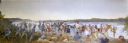
| Description: | Painting by Cal Peters depicting the battle of Bad Axe, also known as the Bad Axe massacre, at the Mississippi River on August 2, 1832. |

| Date: | 06 1962 |
|---|---|
| Description: | U.S. Army advisor Major M.C. Curley and soldiers crossing a river in the delta region of Vietnam in a small boat to visit an outpost. A large building, a m... |

| Date: | 1962 |
|---|---|
| Description: | An American soldier inspects the papers of a Vietnamese man in the countryside along a river. Vietnamese soldiers and a boy are grouped around him. |

| Date: | 11 1961 |
|---|---|
| Description: | Sea Swallows, an anti-communist Vietnamese militia, begin an operation by boats on a canal in the vicinity of Van Dinh, Vietnam. Militia members hold guns ... |

| Date: | 06 1962 |
|---|---|
| Description: | Aerial view of old U.S. Army model H-21 helicopter, assigned to help Vietnamese forces fight the Viet Cong in the mountain region of Vietnam. The patchwork... |

| Date: | 1944 |
|---|---|
| Description: | Continental Transportation Lines, Inc. operating an International semi-truck (tractor-trailer) on a road with a hazy view of a bridge, a body of water and ... |
| Date: | |
|---|---|
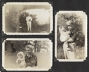
| Description: | Page from Joy Camps photo album displaying three photographs. In one a man poses in a white military uniform holding his hat, with a lake and distant shore... |

| Date: | 1758 |
|---|---|
| Description: | Map showing lakes, rivers, cities, Native American land, and the boundaries of French and English claims in America and Canada north of New York. A title c... |

| Date: | 1755 |
|---|---|
| Description: | Map of New England, with three inset maps of Fort Oswego, Fort du Quesne, and Fort Frederick. It shows colonies, a few cities, forts (marked as French or E... |
If you didn't find the material you searched for, our Library Reference Staff can help.
Call our reference desk at 608-264-6535 or email us at: