 Filter: Categories of Wisconsin Historical Images
Filter: Subject of War
Filter: Subject of transportation
Filter: Subject of political science
Filter: Categories of Wisconsin Historical Images
Filter: Subject of War
Filter: Subject of transportation
Filter: Subject of political science
| Date: | |
|---|---|
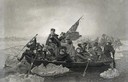
| Description: | Engraving of George Washington and his troops rowing across an icy Delaware River to attack the British, from the painting by E. Leutze. |
| Date: | |
|---|---|
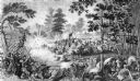
| Description: | Steel engraving of the first major battle of the Civil War, fought in Virginia, near the Manassas, Virginia, railway junction, after which the battle is ca... |

| Date: | 1855 |
|---|---|
| Description: | Map reads "Our Country" which is accompanied by a sailor with a flag to the left and workers rejoicing under the Constitution and Laws to the right. Across... |
| Date: | 1962 |
|---|---|
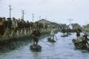
| Description: | Canal in Binh Hung Vietnam with numerous small boats and a crowd of people walking alongside. In the background is a large cross and a number of large that... |

| Date: | 05 1962 |
|---|---|
| Description: | Vietnamese Rangers escort a newly captured prisoner suspected of being Viet Cong down a gravel road in the vicinity of Bac Lien, Vietnam. The prisoner has ... |
| Date: | |
|---|---|
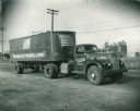
| Description: | International KR-11 truck on a paved road. The trailer is decorated with two large images of the U.S. flag. Original caption reads: "FREIGHT HAULING Intern... |
| Date: | |
|---|---|
| Description: | The fife and drum are not so innocent the vulture's eye is on the dance |

| Date: | 1740 |
|---|---|
| Description: | Engraved and hand-colored map of the Iberian peninsula as a theater of war during the War of the Spanish Succession (1701-1714). The map is dedicated to Ki... |

| Date: | 05 01 1899 |
|---|---|
| Description: | Map showing the Schuylkill River with roads, ferries, and points of interest from Valley Forge to Philadelphia, Pennsylvania as it appeared during the Revo... |

| Date: | 1758 |
|---|---|
| Description: | Map showing lakes, rivers, cities, Native American land, and the boundaries of French and English claims in America and Canada north of New York. A title c... |

| Date: | 1755 |
|---|---|
| Description: | Map of colonial America, showing the lands north of South Carolina and west of the Mississippi River. An inset map of the Carolinas and Georgia sits in the... |

| Date: | |
|---|---|
| Description: | Poster opposing military aid to the government of El Salvador featuring an illustration of silhouetted helicopters spraying red gas towards two people in s... |
If you didn't find the material you searched for, our Library Reference Staff can help.
Call our reference desk at 608-264-6535 or email us at: