 Filter: Categories of Wisconsin Historical Images
Filter: Subject of War
Filter: Subject of roads
Filter: Categories of Wisconsin Historical Images
Filter: Subject of War
Filter: Subject of roads
| Date: | |
|---|---|
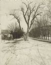
| Description: | The Black Hawk Tree growing in the middle of the street, now East Black Hawk Avenue. There are houses on the left and the road is lined with trees planted... |
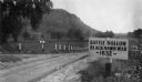
| Date: | 1927 |
|---|---|
| Description: | View of the Battle Hollow sign along an unpaved road. In the distance on the left is a rock formation covered with trees. Sign reads: "Battle Hollow Clack ... |

| Date: | 09 1918 |
|---|---|
| Description: | Elevated view of the U.S. Government War Exposition at Grant Park taken from a window the International Harvester building on Michigan Avenue. A large crow... |

| Date: | 1958 |
|---|---|
| Description: | 26th of July Movement soldiers on patrol in Oriente Province during the Cuban Revolution. One soldier is walking along a dirt road carrying a large automat... |

| Date: | 05 1961 |
|---|---|
| Description: | Aerial view of the town of Luang Prabang, Laos. Trees are interspersed among houses and roads and green mountains encircle the town. The golden roof of Pho... |

| Date: | 1961 |
|---|---|
| Description: | Aerial view of a small settlement in the mountains, Luang Prabang vicinity, Laos. A narrow dirt road winds across the terrain and some buildings and an air... |

| Date: | 1961 |
|---|---|
| Description: | A woman carrying a basket on her back leads a mule laden with bundles across an airstrip at Keukacham village, Laos. There are 55-gallon drums near a tent,... |

| Date: | 1961 |
|---|---|
| Description: | View of Keukacham village, Laos from behind a tank. A partially thatched building is in the foreground and other buildings on a dirt road are visible in th... |

| Date: | 1961 |
|---|---|
| Description: | Aerial view of Keukacham village, Laos including landing strip with helicopter. The small settlement is clearly visible contrasted against the verdant gree... |
| Date: | 1967 |
|---|---|
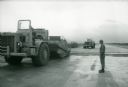
| Description: | A man stands beside an International 270 pay scraper at Phan Rang, an air base in South Vietnam. |
| Date: | 06 1962 |
|---|---|
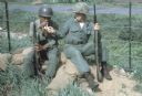
| Description: | Two soldiers under the command of U.S. Army advisor Major M.C. Curley in the delta region of Vietnam sitting on sandbags smoking cigarettes. The soldiers ... |

| Date: | 1944 |
|---|---|
| Description: | Continental Transportation Lines, Inc. operating an International semi-truck (tractor-trailer) on a road with a hazy view of a bridge, a body of water and ... |

| Date: | 05 01 1899 |
|---|---|
| Description: | Map showing the Schuylkill River with roads, ferries, and points of interest from Valley Forge to Philadelphia, Pennsylvania as it appeared during the Revo... |

| Date: | 1998 |
|---|---|
| Description: | This map shows an auto tour route with historical markers and the approximate Black Hawk Band route in southern Wisconsin. County boundaries, roads and cit... |

| Date: | 1780 |
|---|---|
| Description: | Detailed topographical and political map of the area from Lake Champlain to Albany and the Hudson River. Relief is shown through hachures. The map shows ci... |

| Date: | 10 1776 |
|---|---|
| Description: | Broadside map showing the British invasion of New York city in August and September of 1776. The map shows important cities, forts, roads, hills, mountains... |

| Date: | 1781 |
|---|---|
| Description: | Map of the southern portion of the Chesapeake Bay and surrounding lands. It shows counties, a few cities and towns, forts, roads, islands, topographical fe... |
If you didn't find the material you searched for, our Library Reference Staff can help.
Call our reference desk at 608-264-6535 or email us at: