 Filter: Categories of Wisconsin Historical Images
Filter: Subject of War
Filter: Subject of political science
Filter: Subject of rivers
Filter: Categories of Wisconsin Historical Images
Filter: Subject of War
Filter: Subject of political science
Filter: Subject of rivers
| Date: | |
|---|---|
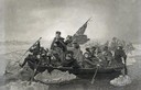
| Description: | Engraving of George Washington and his troops rowing across an icy Delaware River to attack the British, from the painting by E. Leutze. |

| Date: | 1855 |
|---|---|
| Description: | Map reads "Our Country" which is accompanied by a sailor with a flag to the left and workers rejoicing under the Constitution and Laws to the right. Across... |

| Date: | 05 1962 |
|---|---|
| Description: | Vietnamese Rangers escort a newly captured prisoner suspected of being Viet Cong down a gravel road in the vicinity of Bac Lien, Vietnam. The prisoner has ... |

| Date: | 05 01 1899 |
|---|---|
| Description: | Map showing the Schuylkill River with roads, ferries, and points of interest from Valley Forge to Philadelphia, Pennsylvania as it appeared during the Revo... |

| Date: | 1758 |
|---|---|
| Description: | This detailed map of north eastern America shows the boundaries, cities, mountains, rivers, lakes, Native American land and towns, and roads from east of t... |

| Date: | 1758 |
|---|---|
| Description: | Map showing lakes, rivers, cities, Native American land, and the boundaries of French and English claims in America and Canada north of New York. A title c... |

| Date: | 1755 |
|---|---|
| Description: | Map of colonial America, showing the lands north of South Carolina and west of the Mississippi River. An inset map of the Carolinas and Georgia sits in the... |

| Date: | 1777 |
|---|---|
| Description: | Map of Colonial America east of Lake Michigan showing regions, cities, forts, Native American land, mountains, lakes, and rivers. Crossed swords and small ... |
If you didn't find the material you searched for, our Library Reference Staff can help.
Call our reference desk at 608-264-6535 or email us at: