 Filter: Categories of Wisconsin Historical Images
Filter: Subject of War
Filter: Subject of islands
Filter: Categories of Wisconsin Historical Images
Filter: Subject of War
Filter: Subject of islands
| Date: | 1945 |
|---|---|
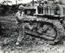
| Description: | Marine Private First Class Gilbert E. Bailey shovels heavily caked mud from the tracks of his International TD-18 Diesel crawler tractor (TracTracTor). The... |
| Date: | 1945 |
|---|---|
| Description: | Marines use an International TD-18 Diesel crawler tractor (TracTracTor) to pull an ammunition trailer from the mud. The original caption reads: "JAPANESE A... |
| Date: | 1945 |
|---|---|
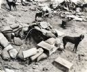
| Description: | Three dogs near a sandbagged foxhole during the battle of Iwo Jima. A marine is near another dog behind the foxhole. Wooden boxes in the foreground have wr... |
| Date: | 1945 |
|---|---|
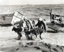
| Description: | Three marines dressed in uniform, carrying packs and holding guns, pull an ammunition cart through the water towards the beach at Iwo Jima. Military boats ... |
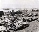
| Date: | 1945 |
|---|---|
| Description: | Marines, killed in action, lie on stretchers covered with ponchos on the beach at Iwo Jima. Four marines attend to the dead. Tents, military boats, and an ... |
| Date: | 02 19 1945 |
|---|---|
| Description: | Marines on the beach and military boats, including an LSM 242, in the water at Iwo Jima. |
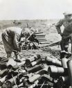
| Date: | 1945 |
|---|---|
| Description: | Private First Class Anthony R. Buzzelli opens an ammunition box with an axe for Marines battling on Iwo Jima. Another man on the right appears to be openin... |
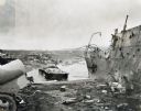
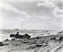
| Date: | 1945 |
|---|---|
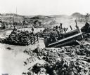
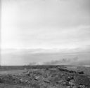
| Description: | Parts of destroyed boats and military equipment on the shoreline of Iwo Jima on D-Day. |
| Date: | 1945 |
|---|---|
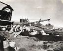
| Description: | Marines dig foxholes into the sand on the beaches of Iwo Jima. The men are surrounded by military equipment, including a crane. An International Diesel cra... |
| Date: | 08 31 1944 |
|---|---|
| Description: | Smoke rising from Cezembre Island, just north of Saint-Malo on the north coast of France. The island, which took a tremendous shelling, can barely be seen ... |

| Date: | 1740 |
|---|---|
| Description: | Engraved and hand-colored map of the Iberian peninsula as a theater of war during the War of the Spanish Succession (1701-1714). The map is dedicated to Ki... |

| Date: | 05 01 1899 |
|---|---|
| Description: | Map showing the Schuylkill River with roads, ferries, and points of interest from Valley Forge to Philadelphia, Pennsylvania as it appeared during the Revo... |

| Date: | 1760 |
|---|---|
| Description: | Map showing upstate New York, Lake Ontario, and the St. Lawrence River during the last, decisive battle of the French and Indian War. The main map shows a ... |

| Date: | 10 1776 |
|---|---|
| Description: | Broadside map showing the British invasion of New York city in August and September of 1776. The map shows important cities, forts, roads, hills, mountains... |

| Date: | 1781 |
|---|---|
| Description: | Map of the southern portion of the Chesapeake Bay and surrounding lands. It shows counties, a few cities and towns, forts, roads, islands, topographical fe... |
If you didn't find the material you searched for, our Library Reference Staff can help.
Call our reference desk at 608-264-6535 or email us at: