 Filter: Categories of Wisconsin Historical Images
Filter: Subject of War
Filter: Subject of indians of north america
Filter: Subject of transportation
Filter: Categories of Wisconsin Historical Images
Filter: Subject of War
Filter: Subject of indians of north america
Filter: Subject of transportation

| Date: | 1852 |
|---|---|
| Description: | Illustration of the Ojibwa, the Sacs, and Foxes battling from canoes on the water. |
| Date: | |
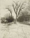
|---|---|
| Description: | The Black Hawk Tree growing in the middle of the street, now East Black Hawk Avenue. There are houses on the left and the road is lined with trees planted... |

| Date: | 1998 |
|---|---|
| Description: | This map shows an auto tour route with historical markers and the approximate Black Hawk Band route in southern Wisconsin. County boundaries, roads and cit... |

| Date: | 1758 |
|---|---|
| Description: | Map showing lakes, rivers, cities, Native American land, and the boundaries of French and English claims in America and Canada north of New York. A title c... |

| Date: | 1755 |
|---|---|
| Description: | Map of colonial America, showing the lands north of South Carolina and west of the Mississippi River. An inset map of the Carolinas and Georgia sits in the... |

| Date: | 1760 |
|---|---|
| Description: | Map showing upstate New York, Lake Ontario, and the St. Lawrence River during the last, decisive battle of the French and Indian War. The main map shows a ... |
If you didn't find the material you searched for, our Library Reference Staff can help.
Call our reference desk at 608-264-6535 or email us at: