 Filter: Categories of Wisconsin Historical Images
Filter: Subject of War
Filter: Subject of indians of north america
Filter: Subject of land
Filter: Categories of Wisconsin Historical Images
Filter: Subject of War
Filter: Subject of indians of north america
Filter: Subject of land
| Date: | |
|---|---|
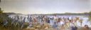
| Description: | Painting by Cal Peters depicting the battle of Bad Axe, also known as the Bad Axe massacre, at the Mississippi River on August 2, 1832. |

| Date: | 1852 |
|---|---|
| Description: | Illustration of the Ojibwa, the Sacs, and Foxes battling from canoes on the water. |

| Date: | |
|---|---|
| Description: | A map of southern Wisconsin and northern Illinois showing where the battles took place and routes taken by Black Hawk and his band during the Black Hawk Wa... |

| Date: | 1758 |
|---|---|
| Description: | This detailed map of north eastern America shows the boundaries, cities, mountains, rivers, lakes, Native American land and towns, and roads from east of t... |

| Date: | 1755 |
|---|---|
| Description: | Map of colonial America, showing the lands north of South Carolina and west of the Mississippi River. An inset map of the Carolinas and Georgia sits in the... |

| Date: | 1777 |
|---|---|
| Description: | Map of Colonial America east of Lake Michigan showing regions, cities, forts, Native American land, mountains, lakes, and rivers. Crossed swords and small ... |

| Date: | 1795 |
|---|---|
| Description: | Map of the United States east of the Mississippi River. It features roads, cities, towns, early settlements, Native American land, forts, mountains, rivers... |

| Date: | 1760 |
|---|---|
| Description: | Map showing upstate New York, Lake Ontario, and the St. Lawrence River during the last, decisive battle of the French and Indian War. The main map shows a ... |
If you didn't find the material you searched for, our Library Reference Staff can help.
Call our reference desk at 608-264-6535 or email us at: