Filter: Categories of Wisconsin Historical Images
Filter: Subject of War
Filter: Subject of fortification
Filter: Categories of Wisconsin Historical Images
Filter: Subject of War
Filter: Subject of fortification
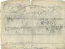
| Date: | 10 03 1862 |
|---|---|
| Description: | "Combined Confederate attack upon [Batteries] Robinette and Davis the attack on Battery Robinette being defeated and that on Davis resulting in the defeat ... |
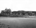
| Date: | |
|---|---|
| Description: | A view of the ruins of Fort Sumter from across a road showing a set of stairs leading up to a building. A path leads to other buildings which remain intact... |
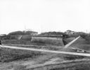
| Date: | |
|---|---|
| Description: | A view of Fort Moultrie from across a body of water. A doorway leads into the fort, and to the left a sign reads, "Cable Crossing Do Not Anchor." Past the ... |

| Date: | |
|---|---|
| Description: | An article discussing a new device to protect Union infantry from the enemy while they are advancing. |
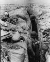
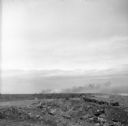
| Date: | 03 25 1954 |
|---|---|
| Description: | Note on the back: "Defenders dig in. Dien Bien Phu, Indochina: An airport once covered this area where soldiers have dug deep trenches as protection from b... |
| Date: | 08 31 1944 |
|---|---|
| Description: | Smoke rising from Cezembre Island, just north of Saint-Malo on the north coast of France. The island, which took a tremendous shelling, can barely be seen ... |

| Date: | 1950 |
|---|---|
| Description: | This map shows regions in Northern Illinois and Southern Wisconsin roughly bounded by Lake Winnebago, the Kankakee River, Peoria, and Prairie du Chien. The... |

| Date: | 1755 |
|---|---|
| Description: | Map of New England, with three inset maps of Fort Oswego, Fort du Quesne, and Fort Frederick. It shows colonies, a few cities, forts (marked as French or E... |

| Date: | 1760 |
|---|---|
| Description: | Map showing upstate New York, Lake Ontario, and the St. Lawrence River during the last, decisive battle of the French and Indian War. The main map shows a ... |

| Date: | 10 1776 |
|---|---|
| Description: | Broadside map showing the British invasion of New York city in August and September of 1776. The map shows important cities, forts, roads, hills, mountains... |

| Date: | 1781 |
|---|---|
| Description: | Map of the southern portion of the Chesapeake Bay and surrounding lands. It shows counties, a few cities and towns, forts, roads, islands, topographical fe... |
If you didn't find the material you searched for, our Library Reference Staff can help.
Call our reference desk at 608-264-6535 or email us at: