 Filter: Categories of Wisconsin Historical Images
Filter: Subject of War
Filter: Subject of arts
Filter: Subject of transportation
Filter: Categories of Wisconsin Historical Images
Filter: Subject of War
Filter: Subject of arts
Filter: Subject of transportation
| Date: | |
|---|---|
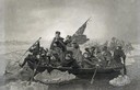
| Description: | Engraving of George Washington and his troops rowing across an icy Delaware River to attack the British, from the painting by E. Leutze. |

| Date: | |
|---|---|
| Description: | Steel engraving of the first major battle of the Civil War, fought in Virginia, near the Manassas, Virginia, railway junction, after which the battle is ca... |

| Date: | 1934 |
|---|---|
| Description: | Poster for an anti-war documentary film written by Burnet Hershey and produced by M.J. Kandel for Ideal Pictures Corp. |
| Date: | 04 1884 |
|---|---|
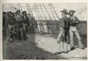
| Description: | An engraving depicting the impressment of American seamen by the British Navy during the period before the War of 1812. The image shows a group of American... |

| Date: | 1740 |
|---|---|
| Description: | Engraved and hand-colored map of the Iberian peninsula as a theater of war during the War of the Spanish Succession (1701-1714). The map is dedicated to Ki... |

| Date: | 05 1854 |
|---|---|
| Description: | This yellow and black wood block print broadside ties England and France's declaration of war against Russia during the Crimean War into a war against high... |

| Date: | 1920 |
|---|---|
| Description: | Aerial view looking over railroad cars on railroad tracks towards an encampment. Signs on a building at the encampment read: "War Exposition," and "Three M... |

| Date: | 1758 |
|---|---|
| Description: | Map showing lakes, rivers, cities, Native American land, and the boundaries of French and English claims in America and Canada north of New York. A title c... |

| Date: | 1755 |
|---|---|
| Description: | Map of colonial America, showing the lands north of South Carolina and west of the Mississippi River. An inset map of the Carolinas and Georgia sits in the... |

| Date: | 1760 |
|---|---|
| Description: | Map showing upstate New York, Lake Ontario, and the St. Lawrence River during the last, decisive battle of the French and Indian War. The main map shows a ... |

| Date: | 1780 |
|---|---|
| Description: | Detailed topographical and political map of the area from Lake Champlain to Albany and the Hudson River. Relief is shown through hachures. The map shows ci... |

| Date: | 10 1776 |
|---|---|
| Description: | Broadside map showing the British invasion of New York city in August and September of 1776. The map shows important cities, forts, roads, hills, mountains... |

| Date: | 1781 |
|---|---|
| Description: | Map of the southern portion of the Chesapeake Bay and surrounding lands. It shows counties, a few cities and towns, forts, roads, islands, topographical fe... |

| Date: | |
|---|---|
| Description: | Poster opposing military aid to the government of El Salvador featuring an illustration of silhouetted helicopters spraying red gas towards two people in s... |
If you didn't find the material you searched for, our Library Reference Staff can help.
Call our reference desk at 608-264-6535 or email us at: