 Filter: Categories of Wisconsin Historical Images
Filter: Subject of Voyages and travels
Filter: Subject of land
Filter: Categories of Wisconsin Historical Images
Filter: Subject of Voyages and travels
Filter: Subject of land
| Date: | 1935 |
|---|---|
| Description: | Original created in 1788, this facsimile map shows the routes traveled by Perrault, an early voyageur in Northern America. |

| Date: | 1775 |
|---|---|
| Description: | This map shows the northern Pacific Ocean along with north eastern Asia and western North America. The interior of Asia contains detailed engravings of pla... |

| Date: | 1788 |
|---|---|
| Description: | This map shows the north western coast of North America, including the southern coast of what will be Alaska and parts of the Aleutian Islands. It includes... |

| Date: | 1769 |
|---|---|
| Description: | Double hemispherical map showing the continents, islands, countries, and a few major cities of the world. The routes of a few explorers are depicted and la... |

| Date: | 1679 |
|---|---|
| Description: | Decorative and detailed map of the eastern half of North America. Regions, cities, colonies, Native America land, rivers, lakes and some nautical features ... |

| Date: | 1724 |
|---|---|
| Description: | Map showing the mountains, rivers, lakes, settlements, islands, and regions of North and South America. Characteristic of de L'Isle, this map is highly det... |

| Date: | 1684 |
|---|---|
| Description: | Map of North America showing some colonies, cities, rivers, lakes, and Native American land. Ship routes spread across both oceans, including one decorated... |

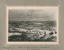
| Date: | 1775 |
|---|---|
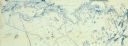
| Description: | This six sheet large format map is one of the most informative maps of its time. It shows cities, Native American land, lakes, rivers, mountains, topograph... |

| Date: | 1777 |
|---|---|
| Description: | This important map highlights the frantic desire and search for the north west passage. It shows a few settlements and mountains in Russia, north west Amer... |
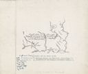
| Date: | 11 22 1919 |
|---|---|
| Description: | Print on card depicting a herd of Bison near Lake Jessie. Written under the title is the date: "July 10th, 1853" and "Shyenne River County." |
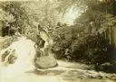
| Date: | 1909 |
|---|---|
| Description: | Two of The Gang carrying a canoe on a portage in the Presque Isle River. |
| Date: | |
|---|---|
| Description: | A geological map of the Rainy Lake region in Minnesota and Ontario. |
| Date: | |
|---|---|
| Description: | A detailed blueprint map showing the route of Howard Greene and The Gang's canoe trip through the Rainy Lake region in 1910. |
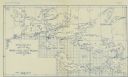
| Date: | 1911 |
|---|---|
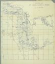
| Description: | A map of St. Louis County, Minnesota that traces the route of Howard Green and The Gang's canoe trip from Tower to Ranier. |
| Date: | |
|---|---|
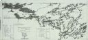
| Description: | A blueprint map with an overlay traced in pencil of the routes of Howard Greene and The Gang's 1910 and 1911 canoe trips. |

| Date: | 12 1927 |
|---|---|
| Description: | View towards a man standing behind a "Saraha" truck. Hills are in the background. |
| Date: | 12 1927 |
|---|---|
| Description: | Outdoor view of a man sitting on the side of a truck, wearing a hat and a cloth over his mouth. |
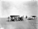
| Date: | 12 1927 |
|---|---|
| Description: | View across sand towards a group of men standing near two trucks in the Sahara Desert. |
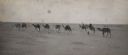
| Date: | 1925 |
|---|---|
| Description: | Sahara expedition team, including Alonzo Pond and Count Byron de Prorok, riding a caravan of camels through the desert. Caption reads: "293 The Expedition ... |

| Date: | 1925 |
|---|---|
| Description: | Hand-colored lantern slide showing a group of men on an archaeological expedition in Algeria pushing one of the expedition vehicles nicknamed "Hot Dog" in ... |
If you didn't find the material you searched for, our Library Reference Staff can help.
Call our reference desk at 608-264-6535 or email us at: