 Filter: Categories of Wisconsin Historical Images
Filter: Subject of Voyages and travels
Filter: Subject of human settlements
Filter: Categories of Wisconsin Historical Images
Filter: Subject of Voyages and travels
Filter: Subject of human settlements
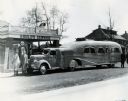
| Date: | 1938 |
|---|---|
| Description: | International "Jungle Yacht" parked at "Gould's" service station on the way from an International Harvester factory to New York City. Explorer Attilio Gatt... |
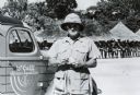
| Date: | 1939 |
|---|---|
| Description: | Commander Attilio Gatti poses in front of a Congolese village during his tenth expedition to Africa. The expedition was sponsored by International Harveste... |
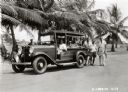
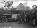
| Date: | 12 19 1933 |
|---|---|
| Description: | A group from the Gold Coast Colony in Acura(?), West Africa, poses with an International Special Delivery truck. The truck was on an expedition sponsored b... |

| Date: | 1947 |
|---|---|
| Description: | Original caption reads: "Gatti-Hallicrafters Expedition being assembled outside Manhattan showrooms of International Harvester Company preparatory to depar... |

| Date: | 1947 |
|---|---|
| Description: | Original caption reads: "Gatti-Hallicrafters Expedition being assembled outside Manhattan showrooms of International Harvester Company preparatory to depar... |

| Date: | 1836 |
|---|---|
| Description: | This map depicts Wisconsin and Michigan territories in 1836. It includes the area from Michigan to the Missouri River and Lake Winnipeg, and it shows the e... |
| Date: | |
|---|---|
| Description: | The fast movement was a nervous reach for something west. But along the way there was no hurry. Wait for noontime, turned round to a movement eastward,<... |
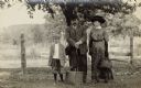
| Date: | 1900 |
|---|---|
| Description: | Group portrait of George, Louise, and Milton, their son, standing in front of a fence. They are traveling with one suitcase and a full handbag. All three a... |
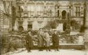
| Date: | 03 14 1930 |
|---|---|
| Description: | Ernst Schmidt, second from left, on a tour of the ruins of Heidelberg Castle with his guide, left, and two unidentified persons. They are standing in the c... |

| Date: | 1775 |
|---|---|
| Description: | This map shows the northern Pacific Ocean along with north eastern Asia and western North America. The interior of Asia contains detailed engravings of pla... |

| Date: | 1790 |
|---|---|
| Description: | An updated and corrected version of Robert de Vaugondy's 1750 map "Amérique Septentrionale: Dressée sur les Relations les Plus Modernes des Voyageurs et Na... |

| Date: | 1769 |
|---|---|
| Description: | Double hemispherical map showing the continents, islands, countries, and a few major cities of the world. The routes of a few explorers are depicted and la... |

| Date: | 1679 |
|---|---|
| Description: | Decorative and detailed map of the eastern half of North America. Regions, cities, colonies, Native America land, rivers, lakes and some nautical features ... |

| Date: | 1724 |
|---|---|
| Description: | Map showing the mountains, rivers, lakes, settlements, islands, and regions of North and South America. Characteristic of de L'Isle, this map is highly det... |

| Date: | 1684 |
|---|---|
| Description: | Map of North America showing some colonies, cities, rivers, lakes, and Native American land. Ship routes spread across both oceans, including one decorated... |

| Date: | 1713 |
|---|---|
| Description: | Map showing the regions explored by Robert de La Salle between 1681 and 1686, as well as the route La Salle, and later Henri Joutel, took, moving north fro... |

| Date: | 1775 |
|---|---|
| Description: | This six sheet large format map is one of the most informative maps of its time. It shows cities, Native American land, lakes, rivers, mountains, topograph... |

| Date: | 1777 |
|---|---|
| Description: | This important map highlights the frantic desire and search for the north west passage. It shows a few settlements and mountains in Russia, north west Amer... |
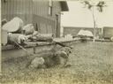
| Date: | 1909 |
|---|---|
| Description: | Carl Greene's dog Nimrod resting on the grass in Watersmeet. There is a chain on his collar, and The Gang's travel supplies, including a cased mandolin, ar... |
| Date: | 12 1927 |
|---|---|
| Description: | "Sahara" trucks in a village in Africa. A man is sitting in the driver's seat of the truck. Villagers, including children, are standing together near the t... |
If you didn't find the material you searched for, our Library Reference Staff can help.
Call our reference desk at 608-264-6535 or email us at: