 Filter: Categories of Wisconsin Historical Images
Filter: Subject of Voyages and travels
Filter: Type of Map or Atlas
Filter: Subject of mississippi river
Filter: Categories of Wisconsin Historical Images
Filter: Subject of Voyages and travels
Filter: Type of Map or Atlas
Filter: Subject of mississippi river

| Date: | 1804 |
|---|---|
| Description: | A map of Lewis and Clark's Track across the western portion of North America from the Mississippi River to the Pacific Ocean by order of the Executive of t... |

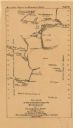
| Date: | 1673 |
|---|---|
| Description: | Facsimile of the autograph map of the Mississippi or Conception River drawn by Father Marquette at the time of his voyage. From the original preserved at S... |

| Date: | 1919 |
|---|---|
| Description: | This map depicts the route of the 1842 overland trip by wagon made by the Reverend Alfred Brunson and some copper miners from Prairie du Chien to the mouth... |
| Date: | 1876 |
|---|---|
| Description: | Between May and September 1673, Father Jacques Marquette and Louis Joliet crossed what is now Wisconsin and traveled down the Mississippi River as far as A... |

| Date: | 1713 |
|---|---|
| Description: | Map showing the regions explored by Robert de La Salle between 1681 and 1686, as well as the route La Salle, and later Henri Joutel, took, moving north fro... |
If you didn't find the material you searched for, our Library Reference Staff can help.
Call our reference desk at 608-264-6535 or email us at: