Map or Atlas
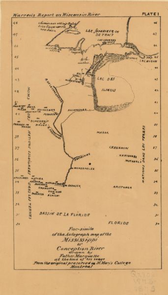
Facsimile of the Autograph Map of the Mississippi or Conception River

| Between May and September 1673, Father Jacques Marquette and Louis Joliet crossed what is now Wisconsin and traveled down the Mississippi River as far as Arkansas before returning; they were the first Europeans to do so. This is a facsimile of a map believed to have been drawn by Father Marquette describing their travels. Recognizable features include Green Bay, the Fox and Wisconsin River portage, and the Mississippi River, called here the Conception. This version of Marquette's map is taken from G.K. Warren's 1876 Report on the transportation route along the Wisconsin and Fox rivers in the State of Wisconsin between the Mississippi River and Lake Michigan. |
| Image ID: | 97898 |
|---|---|
| Creation Date: | 1876 |
| Creator Name: | Marquette, Jacques |
| City: | |
| County: | |
| State: | Wisconsin |
| Collection Name: | Map Collection |
| Genre: | Map or Atlas |
| Original Format Type: | prints, photomechanical |
| Original Format Number: | GX9028 W81 1875 WP (1) |
| Original Dimensions: | each 20 x 12 cm., on sheets 46 x 61 cm. |
| Voyages and travels |
| Land |
| Rivers |
| Mississippi River |
| This image is issued by the Wisconsin Historical Society. Use of the image requires written permission from the staff of the Collections Division. It may not be sold or redistributed, copied or distributed as a photograph, electronic file, or any other media. The image should not be significantly altered through conventional or electronic means. Images altered beyond standard cropping and resizing require further negotiation with a staff member. The user is responsible for all issues of copyright. Please Credit: Wisconsin Historical Society. |
| Location: | Wisconsin Historical Society Archives, 4th Floor, Madison, Wisconsin |
|---|
