 Filter: Categories of Wisconsin Historical Images
Filter: Subject of Transportation
Filter: Subject of geology
Filter: Categories of Wisconsin Historical Images
Filter: Subject of Transportation
Filter: Subject of geology
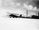
| Date: | 1938 |
|---|---|
| Description: | Curtiss-Wright Condor biplane named "William Horlick" outfitted with skis for use during Adm. Richard E. Byrd's second Antarctic expedition, 1933-35. The ... |

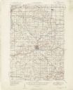
| Date: | 1870 |
|---|---|
| Description: | A geological survey map of Wisconsin, with hand-colored portions showing the surveys completed from 1873 to 1875. Although the title and legend are in Wel... |

| Date: | 1873 |
|---|---|
| Description: | A hand-colored, geological map of the Fox and Wisconsin rivers’ water path from the Mississippi River to the Great Lakes. The map also shows those railroad... |

| Date: | 1874 |
|---|---|
| Description: | A hand-colored, geological map of Wisconsin show the progress of the state geological survey in 1873 and 1874. Other elements displayed in the map include... |

| Date: | 1917 |
|---|---|
| Description: | A geological survey map that shows the sedimentary and igneous deposits in southeastern Wisconsin and south central Wisconsin, as well as the limits of gla... |

| Date: | 1917 |
|---|---|
| Description: | A geological survey map that map of southeastern Wisconsin shows the surface deposits east of the Wisconsin River, from the Illinois state line north to Ne... |

| Date: | 1912 |
|---|---|
| Description: | This map is pen, ink, and pencil on tracing paper. The map was traced from U.S. Geological Survey map of Wisconsin, compiled in 1910-1911, and printed in 1... |

| Date: | 1937 |
|---|---|
| Description: | A pictorial, hydrographic map shows sailing courses, historical and contemporary coastal attractions, roads, and the contour depths of Green Lake, Wisconsi... |

| Date: | 1836 |
|---|---|
| Description: | A detailed map of the mouth of the Kewaunee River, showing the geological composition of the Lake Michigan shoreline and the various water depths in the ar... |

| Date: | 1828 |
|---|---|
| Description: | Increase Lapham's drawing and description of an earth borer for his handwritten manuscript, Notes and Accounts of Canals, Particularly the Ohio Canal Ne... |

| Date: | 1892 |
|---|---|
| Description: | This map shows rivers, lakes, railroad lines, roads, and communities in addition to geological data. The map includes cross-sections in the bottom margin a... |

| Date: | 1910 |
|---|---|
| Description: | This map shows the Soo Line railroad and Arpin Hardwood Lumber Company lands in red. The top margin of the map reads: "Wisconsin, the safest state in the U... |
| Date: | 1955 |
|---|---|
| Description: | This set of 32 maps and an index show the (then) proposed route of the Wisconsin Turnpike. The index shows the entire route of the turnpike, and the major ... |

| Date: | 01 18 2015 |
|---|---|
| Description: | Inside view of display cases of rocks and geodes along the front windows of the store. "Burnie's Rock Shop" is painted in reverse on the window. Two street... |
If you didn't find the material you searched for, our Library Reference Staff can help.
Call our reference desk at 608-264-6535 or email us at: