Filter: Categories of Wisconsin Historical Images
Filter: Subject of Transportation
Filter: Subject of fortification
Filter: Categories of Wisconsin Historical Images
Filter: Subject of Transportation
Filter: Subject of fortification

| Date: | 1936 |
|---|---|
| Description: | This map is red and black ink on tracing cloth and is oriented with north to the upper left. This hand-drawn map shows a central portion of the military ro... |
| Date: | 1849 |
|---|---|
| Description: | Fort Childs or New Fort Kearny in Nebraska Sketched by Wilkins on his 151-day journey from Missouri to California on the Overland Trail (also known as the ... |

| Date: | 1851 |
|---|---|
| Description: | A rare photograph of U.S. Army soldiers stationed at Fort Howard rowing a boat on the Fox River. Fort Howard, built in 1816, was the first in the chain of ... |
| Date: | 05 1849 |
|---|---|
| Description: | Old Fort Kearney (Nebraska City). Sketched by Wilkins on his 151-day journey from Missouri to California on the Overland Trail (also known as the Oregon Tr... |

| Date: | 1842 |
|---|---|
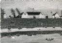
| Description: | This hand-colored lithograph of the second Fort Howard, with Indians canoeing on the Fox River, shows the hospital built 1834-1835 outside the stockade on ... |

| Date: | 10 1829 |
|---|---|
| Description: | Fort Crawford as drawn by Seth Eastman. People are in a canoe in the river in the foreground. Across the river is the fort, other buildings around the fort... |

| Date: | 1835 |
|---|---|
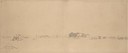
| Description: | Little Lake Butte Des Morts just north of Lake Winnebago where Governor Lewis Cass of Michigan, and Thomas McKenney, head of the Bureau of Indian Affairs (... |

| Date: | 06 24 1849 |
|---|---|
| Description: | Original wash drawing of Fort Laramie, Wyoming (actually Fort John; see note below). Sketched by Wilkins on his 151-day journey from Missouri to California... |
| Date: | 1860 |
|---|---|
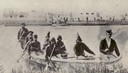
| Description: | Nine men arrive at Fort William by canoe. Fort William, also called Kaministiguia, was the Hudson's Bay fur trading post. Men are standing along the opposi... |

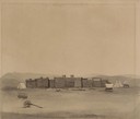
| Date: | 1848 |
|---|---|
| Description: | The first Fort Crawford at Prairie du Chien, with the Mississippi River in the foreground. Although dated 1830, this scene was actually painted by Henry Le... |

| Date: | 1655 |
|---|---|
| Description: | Map from Drake Expedition in Florida, ca. 1585. |
| Date: | 05 1849 |
|---|---|
| Description: | Fort Leavenworth with trees, buildings and American flag. The fort was established by Colonel Henry Leavenworth to protect the Santa Fe trail against the I... |

| Date: | 1833 |
|---|---|
| Description: | Map of part of the military road from Fort Crawford to Fort Howard. "Recorded on pages 668.669 Book B." Surveyed by Lieut. Center. Scale: 2 miles = 1 inch. |
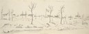
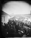
| Date: | 1879 |
|---|---|
| Description: | Elevated view of ornate carriage and animal cage with tents and people looking on at the annual Wisconsin State Fair held at Camp Randall. |
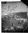
| Date: | 09 10 1879 |
|---|---|
| Description: | Crowd at the Camp Randall fairgrounds watching a horse race, part of that year's Wisconsin State Fair. Carriages and people are near buildings on the left,... |
| Date: | 1820 |
|---|---|
| Description: | Engraving of Fort Dearborn (center) and Kinzie Mansion (right) after Seth Eastman's original drawing in 1820 for the U. S. Army. Several people are visible... |
| Date: | |
|---|---|
| Description: | Photographic copy of a painting depicting Fort Winnebago, made by I. A. Ridgway of Portage, Wisconsin. Fort Winnebago was built in 1827 by Major William W... |

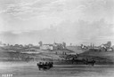
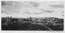
| Date: | 1876 |
|---|---|
| Description: | Elevated view showing Elmore and Kelly's Elevator with a boat, train, and the buildings at Fort Howard. Fort Howard was incorporated into Green Bay. Captio... |
| Date: | 07 25 1849 |
|---|---|
| Description: | Fort Bridger in Wyoming, with wagon parts and teepees, where Wilkins camped for a night; sketched by Wilkins on his 151-day journey from Missouri to Califo... |
If you didn't find the material you searched for, our Library Reference Staff can help.
Call our reference desk at 608-264-6535 or email us at: