 Filter: Categories of Wisconsin Historical Images
Filter: Subject of Trails
Filter: Subject of maps
Filter: Categories of Wisconsin Historical Images
Filter: Subject of Trails
Filter: Subject of maps
| Date: | |
|---|---|
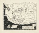
| Description: | A pen drawing, in the style of a birds-eye map, of Frank and Delia King's estate Folly Farm in Kissimee, Florida. |

| Date: | 1920 |
|---|---|
| Description: | This map shows lands owned by the American Immigration Company (red) and the Homeseekers Land Company (green). The map also shows highways, roads, railroad... |

| Date: | 1870 |
|---|---|
| Description: | This map is mostly pencil on paper map but includes latitude and longitude grid in ink. The map covers the Mississippi River from Lake Itasca to the Wiscon... |

| Date: | 1940 |
|---|---|
| Description: | This blue line print map traced from aerial survey mosaic shows reservation boundary, roads, trails, and railroads. Color manuscript annotations show triba... |

| Date: | 1925 |
|---|---|
| Description: | This map shows trails, mounds, villages, corn fields, and contemporary civil townships; some villages and features include both Indian and English place na... |

| Date: | 1975 |
|---|---|
| Description: | This map shows nature trails, public attractions, public hunting and fishing grounds, dams, waysides, lakes, highways, and roads. The upper right corner in... |

| Date: | 1983 |
|---|---|
| Description: | This map covers Vilas county as well as parts of Iron, Oneida, and Forest counties. Club trails are shown in dotted red lines and state trails are shown in... |

| Date: | 1919 |
|---|---|
| Description: | This map contains the automobile routes in southern Wisconsin and northern Illinois. Cities, Lake Winnebago and Green Bay are labeled. The orange print on ... |

| Date: | 1794 |
|---|---|
| Description: | Extremely detailed map of the south-eastern states, south from Virginia and east of the Mississippi River. It shows roads and paths, cities, towns, forts, ... |

| Date: | 1795 |
|---|---|
| Description: | Map of Maine, showing a few cities, harbors, hills, mountains, lakes, and rivers. A road runs from Pownalboro south to Portsmouth harbor, and the boundary ... |
If you didn't find the material you searched for, our Library Reference Staff can help.
Call our reference desk at 608-264-6535 or email us at: